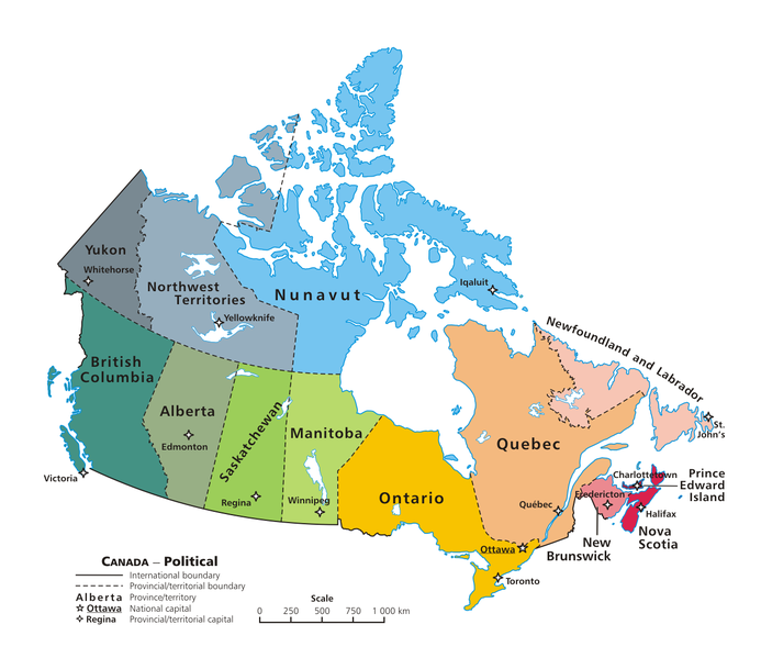
ಚಿತ್ರ:Political map of Canada.png

ಈ ಮುನ್ನೋಟ ಗಾತ್ರ:೬೯೩ × ೫೯೯ ಪಿಕ್ಸೆಲ್ಗಳು. ಇತರ ರೆಸಲ್ಯೂಶನ್ಗಳು: ೨೭೮ × ೨೪೦ ಪಿಕ್ಸೆಲ್ಗಳು | ೫೫೫ × ೪೮೦ ಪಿಕ್ಸೆಲ್ಗಳು | ೮೮೮ × ೭೬೮ ಪಿಕ್ಸೆಲ್ಗಳು | ೧,೧೮೪ × ೧,೦೨೪ ಪಿಕ್ಸೆಲ್ಗಳು | ೧,೨೮೦ × ೧,೧೦೭ ಪಿಕ್ಸೆಲ್ಗಳು.
ಮೂಲ ಕಡತ (೧,೨೮೦ × ೧,೧೦೭ ಚಿತ್ರಬಿಂದು, ಫೈಲಿನ ಗಾತ್ರ: ೨೪೫ KB, MIME ಪ್ರಕಾರ: image/png)
ಕಡತದ ಇತಿಹಾಸ
ದಿನ/ಕಾಲ ಒತ್ತಿದರೆ ಆ ಸಮಯದಲ್ಲಿ ಈ ಕಡತದ ವಸ್ತುಸ್ಥಿತಿ ತೋರುತ್ತದೆ.
| ದಿನ/ಕಾಲ | ಕಿರುನೋಟ | ಆಯಾಮಗಳು | ಬಳಕೆದಾರ | ಟಿಪ್ಪಣಿ | |
|---|---|---|---|---|---|
| ಪ್ರಸಕ್ತ | ೦೮:೨೦, ೧೩ ಜೂನ್ ೨೦೦೭ |  | ೧,೨೮೦ × ೧,೧೦೭ (೨೪೫ KB) | Andrew pmk~commonswiki | optimize png |
| ೦೭:೦೮, ೬ ಜೂನ್ ೨೦೦೭ |  | ೧,೨೮೦ × ೧,೧೦೭ (೨೪೫ KB) | Andrew pmk~commonswiki | optimize png | |
| ೧೫:೦೫, ೬ ಜೂನ್ ೨೦೦೬ |  | ೧,೨೮೦ × ೧,೧೦೭ (೨೯೬ KB) | Kaveh | == Summary == Canada: political map – depicting |provinces/territories and capital cities. Drawn and adapted by E Pluribus Anthony from [http://atlas.gc.ca/site/english/maps/reference/national/can_political_e Atlas |
ಕಡತ ಬಳಕೆ
ಈ ಕೆಳಗಿನ ಪುಟವು ಈ ಚಿತ್ರಕ್ಕೆ ಸಂಪರ್ಕ ಹೊಂದಿದೆ:
ಜಾಗತಿಕ ಕಡತ ಉಪಯೋಗ
ಈ ಕಡತವನ್ನು ಕೆಳಗಿನ ಬೇರೆ ವಿಕಿಗಳೂ ಉಪಯೋಗಿಸುತ್ತಿವೆ:
- af.wikipedia.org ಮೇಲೆ ಬಳಕೆ
- an.wikipedia.org ಮೇಲೆ ಬಳಕೆ
- arc.wikipedia.org ಮೇಲೆ ಬಳಕೆ
- azb.wikipedia.org ಮೇಲೆ ಬಳಕೆ
- کانادا
- مونترئال
- کلگری
- برولینگتون، اونتاریو
- اوکویل
- ریچموند هیل، اونتاریو
- ریچموند، بریتیش کولومبیا
- وینزر، اونتاریو
- کیچنر
- ساسکاتون
- بورنابی
- لونگوی
- گاتینو
- وان (کانادا)
- مارکام، اونتاریو
- لاوال، کبئک
- سوری، بریتیش کولومبیا
- همیلتون، اونتاریو
- برمپتون، اونتاریو
- ونکوور
- میسیساگا
- بلویل، اونتاریو
- دولار-ده-اورمو
- شاوینیگان
- سارنیا
- کاوارتا لیکس
- سو سنتماری
- میپل ریج
- چیلیوک
- پیتربورو، اونتاریو
- بروسارد
- نیومارکت، اونتاریو
- رپانتینی، کبئک
- نیاگارا فالز، اونتاریو
- لثبریج
- نانایمو
- میلتون
- قوزئی ونکوور
- کلارینگتون
- کملوپس
- سن-ژان-سور-ریشولیو
- استراثکونا
- برنتفورد، اونتاریو
- کئیپ برتون
- واترلو، اونتاریو
- دلتا، بریتیش کولومبیا
- چاتهام-کنت، اونتاریو
ಈ ಫೈಲ್ನ ಹೆಚ್ಚು ಜಾಗತಿಕ ಬಳಕೆಯನ್ನು ವೀಕ್ಷಿಸಿ.


