
ಚಿತ್ರ:Physical Map of Europe.jpg
ಇದಕ್ಕಿಂತ ಹೆಚ್ಚಿನ ವಿವರವಾದ ನೋಟ ಇಲ್ಲ.
Physical_Map_of_Europe.jpg (೭೧೯ × ೪೭೬ ಚಿತ್ರಬಿಂದು, ಫೈಲಿನ ಗಾತ್ರ: ೧೮೫ KB, MIME ಪ್ರಕಾರ: image/jpeg)
ಈ ಫೈಲು ವಿಕಿಮೀಡಿಯ ಕಾಮನ್ಸ್ನಲ್ಲಿ ಇರುವುದು. ಅಲ್ಲಿನ ವಿವರಣೆ ಪುಟವನ್ನೇ ಕೆಳಗೆ ತೋರಿಸಲಾಗಿದೆ. ಕಾಮನ್ಸ್ ಕೃತಿಸ್ವಾಮ್ಯತೆಯಿಂದ ಮುಕ್ತ ಫೈಲುಗಳ ಒಂದು ಆಗರ. ಅಲ್ಲಿ ನೀವೂ ಸಹಕರಿಸಬಹುದು. |
- Extended map (enlarged labels): Image:Europe_terrain_CIA_map_extended.jpg.
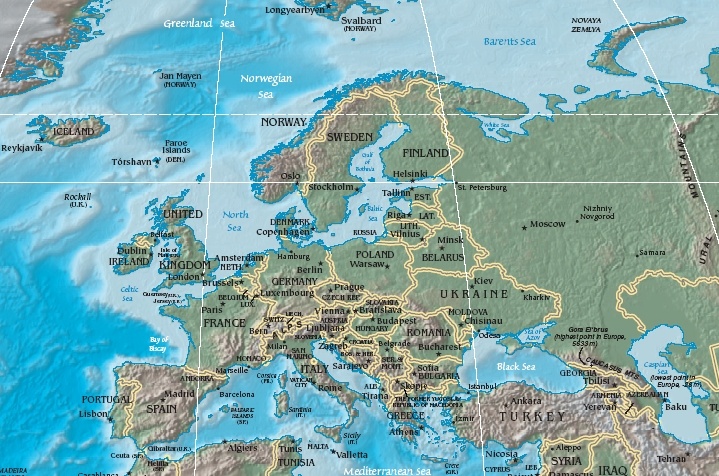
ಸಾರಾಂಶ
| ವಿವರ | Terrain map of Europe, as cropping from the CIA's Physical Map of the World. |
| ದಿನಾಂಕ | Map dated April 2008 |
| ಆಕರ |
Cropped section from the CIA's Physical Map of the World, formerly available at: but moved to webpage (March 2009): Those webpage URLs require secure-post ("https"), for access, because those pages are encrypted. The larger image this one was cropped from may or may not still be available. |
| ಕರ್ತೃ | work of U.S. CIA |
| ಇತರೆ ಆವೃತ್ತಿಗಳು |
Same map in expanded form (more labels):
|
ಪರವಾನಗಿ
This image is in the public domain because it contains materials that originally came from the United States Central Intelligence Agency's World Factbook.
|
 |
ಕಡತದ ಇತಿಹಾಸ
ದಿನ/ಕಾಲ ಒತ್ತಿದರೆ ಆ ಸಮಯದಲ್ಲಿ ಈ ಕಡತದ ವಸ್ತುಸ್ಥಿತಿ ತೋರುತ್ತದೆ.
| ದಿನ/ಕಾಲ | ಕಿರುನೋಟ | ಆಯಾಮಗಳು | ಬಳಕೆದಾರ | ಟಿಪ್ಪಣಿ | |
|---|---|---|---|---|---|
| ಪ್ರಸಕ್ತ | ೧೭:೨೬, ೧೯ ಅಕ್ಟೋಬರ್ ೨೦೦೫ | | ೭೧೯ × ೪೭೬ (೧೮೫ KB) | Grillo | Physical map of Europe. Cropped from http://cia.gov/cia/publications/factbook/reference_maps/pdf/physical_world.pdf and converted to JPG. From en:Image:Physical Map of Europe.jpg {{PD-USGov-CIA-WF}} |
ಕಡತ ಬಳಕೆ
ಈ ಫೈಲನ್ನು ಬಳಸುವ ಯಾವ ಪುಟಗಳೂ ಇಲ್ಲ.
ಜಾಗತಿಕ ಕಡತ ಉಪಯೋಗ
ಈ ಕಡತವನ್ನು ಕೆಳಗಿನ ಬೇರೆ ವಿಕಿಗಳೂ ಉಪಯೋಗಿಸುತ್ತಿವೆ:
- as.wikipedia.org ಮೇಲೆ ಬಳಕೆ
- bat-smg.wikipedia.org ಮೇಲೆ ಬಳಕೆ
- bg.wiktionary.org ಮೇಲೆ ಬಳಕೆ
- cy.wikipedia.org ಮೇಲೆ ಬಳಕೆ
- da.wikipedia.org ಮೇಲೆ ಬಳಕೆ
- Sveriges geografi
- Norges geografi
- Danmarks geografi
- Frankrigs geografi
- Irlands geografi
- Liechtensteins geografi
- Tysklands geografi
- Østrigs geografi
- Europas geografi
- Slovakiets geografi
- Monacos geografi
- Tjekkiets geografi
- Sloveniens geografi
- Storbritanniens geografi
- Tyrkiets geografi
- Schweiz' geografi
- Skabelon:Europas geografi
- Hollands geografi
- Ukraines geografi
- Grækenlands geografi
- de.wikipedia.org ಮೇಲೆ ಬಳಕೆ
- el.wikipedia.org ಮೇಲೆ ಬಳಕೆ
- en.wikipedia.org ಮೇಲೆ ಬಳಕೆ
- es.wikipedia.org ಮೇಲೆ ಬಳಕೆ
- es.wikibooks.org ಮೇಲೆ ಬಳಕೆ
- fr.wikipedia.org ಮೇಲೆ ಬಳಕೆ
- id.wikipedia.org ಮೇಲೆ ಬಳಕೆ
- it.wikipedia.org ಮೇಲೆ ಬಳಕೆ
- ko.wikiquote.org ಮೇಲೆ ಬಳಕೆ
- ky.wikipedia.org ಮೇಲೆ ಬಳಕೆ
- lrc.wikipedia.org ಮೇಲೆ ಬಳಕೆ
- map-bms.wikipedia.org ಮೇಲೆ ಬಳಕೆ
- mk.wikipedia.org ಮೇಲೆ ಬಳಕೆ
ಈ ಫೈಲ್ನ ಹೆಚ್ಚು ಜಾಗತಿಕ ಬಳಕೆಯನ್ನು ವೀಕ್ಷಿಸಿ.