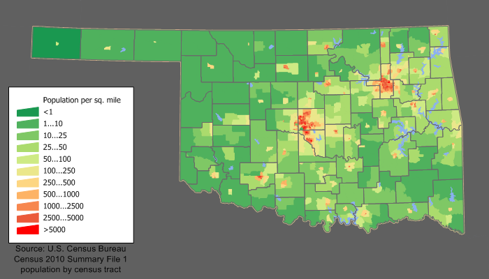
ಚಿತ್ರ:Oklahoma population map.png
Oklahoma_population_map.png (೭೦೦ × ೪೦೦ ಚಿತ್ರಬಿಂದು, ಫೈಲಿನ ಗಾತ್ರ: ೧೨೩ KB, MIME ಪ್ರಕಾರ: image/png)
ಕಡತದ ಇತಿಹಾಸ
ದಿನ/ಕಾಲ ಒತ್ತಿದರೆ ಆ ಸಮಯದಲ್ಲಿ ಈ ಕಡತದ ವಸ್ತುಸ್ಥಿತಿ ತೋರುತ್ತದೆ.
| ದಿನ/ಕಾಲ | ಕಿರುನೋಟ | ಆಯಾಮಗಳು | ಬಳಕೆದಾರ | ಟಿಪ್ಪಣಿ | |
|---|---|---|---|---|---|
| ಪ್ರಸಕ್ತ | ೨೦:೦೦, ೧೧ ಡಿಸೆಂಬರ್ ೨೦೧೧ |  | ೭೦೦ × ೪೦೦ (೧೨೩ KB) | JimIrwin | 2010 census update |
| ೨೩:೪೪, ೨೦ ಏಪ್ರಿಲ್ ೨೦೦೮ |  | ೬೭೨ × ೪೩೦ (೨೬ KB) | File Upload Bot (Magnus Manske) | {{BotMoveToCommons|en.wikipedia}} {{Information |Description={{en|en:Category:U.S. State Population Maps en:Category:Oklahoma maps Oklahoma state population density map based on Census 2000 data. See the [[:en:User:JimIrwin/Lineage_of_populati |
ಕಡತ ಬಳಕೆ
ಈ ಕೆಳಗಿನ ಪುಟವು ಈ ಚಿತ್ರಕ್ಕೆ ಸಂಪರ್ಕ ಹೊಂದಿದೆ:
ಜಾಗತಿಕ ಕಡತ ಉಪಯೋಗ
ಈ ಕಡತವನ್ನು ಕೆಳಗಿನ ಬೇರೆ ವಿಕಿಗಳೂ ಉಪಯೋಗಿಸುತ್ತಿವೆ:
- cy.wikipedia.org ಮೇಲೆ ಬಳಕೆ
- de.wikipedia.org ಮೇಲೆ ಬಳಕೆ
- el.wikipedia.org ಮೇಲೆ ಬಳಕೆ
- en.wikipedia.org ಮೇಲೆ ಬಳಕೆ
- fo.wikipedia.org ಮೇಲೆ ಬಳಕೆ
- fr.wikipedia.org ಮೇಲೆ ಬಳಕೆ
- gu.wikipedia.org ಮೇಲೆ ಬಳಕೆ
- he.wikipedia.org ಮೇಲೆ ಬಳಕೆ
- hu.wikipedia.org ಮೇಲೆ ಬಳಕೆ
- incubator.wikimedia.org ಮೇಲೆ ಬಳಕೆ
- ro.wikipedia.org ಮೇಲೆ ಬಳಕೆ
- Tulsa, Oklahoma
- Categorie:Statul Oklahoma, SUA
- Oklahoma
- Oklahoma City
- Categorie:Formate Oklahoma
- Categorie:Membri ai Senatului SUA din statul Oklahoma
- Categorie:Liste Oklahoma
- Categorie:Comitate din statul Oklahoma, SUA
- Categorie:Guvernul statului Oklahoma
- Listă de orașe din statul Oklahoma
- Categorie:Zone metropolitane din Oklahoma
- Categorie:Zone micropolitane din Oklahoma
- Listă de comitate din statul Oklahoma
- Norman, Oklahoma
- Categorie:Localități din Oklahoma
- Categorie:Membri ai Camerei Reprezentanților SUA din statul Oklahoma
- Categorie:Orașe din Oklahoma
- Categorie:Forme de relief din Oklahoma
- Categorie:Cultura statului Oklahoma
- Categorie:Regiuni ale statului Oklahoma
- Categorie:Comitatul Canadian, Oklahoma
- Categorie:Comitatul Cleveland, Oklahoma
- Categorie:Comitatul Osage, Oklahoma
- Categorie:Comitatul Tulsa, Oklahoma
- Categorie:Comitatul Rogers, Oklahoma
- Categorie:Comitatul Wagoner, Oklahoma
- Categorie:Comitatul Oklahoma, Oklahoma
- Ark-La-Tex
- Listă de comunități neîncorporate din statul Oklahoma
- Listă de localități dispărute din statul Oklahoma
- Listă de comunități desemnate pentru recensământ din statul Oklahoma
- Listă de localități mici din statul Oklahoma
- Categorie:Politicieni din statul Oklahoma
- Comitatul Canadian, Oklahoma
- Categorie:Membri ai legislaturii statului Oklahoma
- Categorie:Localități din Oklahoma după comitat
ಈ ಫೈಲ್ನ ಹೆಚ್ಚು ಜಾಗತಿಕ ಬಳಕೆಯನ್ನು ವೀಕ್ಷಿಸಿ.


