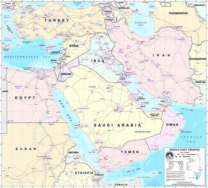
ಚಿತ್ರ:Middle east graphic 2003.jpg

ಈ ಮುನ್ನೋಟ ಗಾತ್ರ:೬೬೪ × ೬೦೦ ಪಿಕ್ಸೆಲ್ಗಳು. ಇತರ ರೆಸಲ್ಯೂಶನ್ಗಳು: ೨೬೬ × ೨೪೦ ಪಿಕ್ಸೆಲ್ಗಳು | ೫೩೨ × ೪೮೦ ಪಿಕ್ಸೆಲ್ಗಳು | ೮೫೦ × ೭೬೮ ಪಿಕ್ಸೆಲ್ಗಳು | ೧,೧೩೪ × ೧,೦೨೪ ಪಿಕ್ಸೆಲ್ಗಳು | ೨,೨೬೮ × ೨,೦೪೮ ಪಿಕ್ಸೆಲ್ಗಳು | ೨,೯೭೩ × ೨,೬೮೫ ಪಿಕ್ಸೆಲ್ಗಳು.
ಮೂಲ ಕಡತ (೨,೯೭೩ × ೨,೬೮೫ ಚಿತ್ರಬಿಂದು, ಫೈಲಿನ ಗಾತ್ರ: ೩.೯೧ MB, MIME ಪ್ರಕಾರ: image/jpeg)
ಕಡತದ ಇತಿಹಾಸ
ದಿನ/ಕಾಲ ಒತ್ತಿದರೆ ಆ ಸಮಯದಲ್ಲಿ ಈ ಕಡತದ ವಸ್ತುಸ್ಥಿತಿ ತೋರುತ್ತದೆ.
| ದಿನ/ಕಾಲ | ಕಿರುನೋಟ | ಆಯಾಮಗಳು | ಬಳಕೆದಾರ | ಟಿಪ್ಪಣಿ | |
|---|---|---|---|---|---|
| ಪ್ರಸಕ್ತ | ೦೪:೦೦, ೯ ಫೆಬ್ರವರಿ ೨೦೧೨ |  | ೨,೯೭೩ × ೨,೬೮೫ (೩.೯೧ MB) | M0tty | Remove compression artefacts by a bilateral filtering. |
| ೦೩:೧೩, ೧೫ ಜುಲೈ ೨೦೦೬ |  | ೨,೯೭೩ × ೨,೬೮೫ (೧,೦೧೩ KB) | Unquietwiki | ''Courtesy of the University of Texas Libraries, The University of Texas at Austin'' [http://www.lib.utexas.edu/maps/middle_east.html http://www.lib.utexas.edu/maps/middle_east.html] High-resolution political / railway / roadmap of the Middle East. |
ಕಡತ ಬಳಕೆ
ಈ ಕೆಳಗಿನ 2 ಪುಟಗಳು ಈ ಚಿತ್ರಕ್ಕೆ ಸಂಪರ್ಕ ಹೊಂದಿವೆ:
ಜಾಗತಿಕ ಕಡತ ಉಪಯೋಗ
ಈ ಕಡತವನ್ನು ಕೆಳಗಿನ ಬೇರೆ ವಿಕಿಗಳೂ ಉಪಯೋಗಿಸುತ್ತಿವೆ:
- ar.wikipedia.org ಮೇಲೆ ಬಳಕೆ
- ويكيبيديا:قوالب/بذور
- ويكيبيديا:قوالب/بذور/جدول بذرة 1
- قالب:بذرة جغرافيا الشرق الأوسط
- بادية الشام
- محافظة العاصمة (البحرين)
- خليج عدن
- دزفول
- زاغروس
- مسجد سليمان
- زاينده
- مسرح أحداث الشرق الأوسط خلال الحرب العالمية الثانية
- الحويزة (مدينة)
- قائمة جزر الخليج العربي
- شرق المتوسط
- قائمة نزاعات الشرق الأوسط الحديثة
- مستخدم:Adnanzoom/مساعدات
- عبد الله بن سعيد
- قرار مجلس الأمن التابع للأمم المتحدة رقم 1381
- مستخدم:ASammour/بذرة-بوابة
- شرف الدين بن الحسن
- فخر الدين بن عدي
- صخر بن صخر بن مسافر
- قالب:بذرة أعلام الشرق الأوسط
- أبجر التاسع
- arz.wikipedia.org ಮೇಲೆ ಬಳಕೆ
- ba.wikipedia.org ಮೇಲೆ ಬಳಕೆ
- be.wikipedia.org ಮೇಲೆ ಬಳಕೆ
- bn.wikipedia.org ಮೇಲೆ ಬಳಕೆ
- ca.wikipedia.org ಮೇಲೆ ಬಳಕೆ
- ce.wikipedia.org ಮೇಲೆ ಬಳಕೆ
- ckb.wikipedia.org ಮೇಲೆ ಬಳಕೆ
- el.wikipedia.org ಮೇಲೆ ಬಳಕೆ
- en.wikipedia.org ಮೇಲೆ ಬಳಕೆ
ಈ ಫೈಲ್ನ ಹೆಚ್ಚು ಜಾಗತಿಕ ಬಳಕೆಯನ್ನು ವೀಕ್ಷಿಸಿ.


