
ಚಿತ್ರ:Maharashtra Divisions Eng.svg

Size of this PNG preview of this SVG file: ೭೫೯ × ೫೯೯ ಪಿಕ್ಸೆಲ್ಗಳು. ಇತರ ರೆಸಲ್ಯೂಶನ್ಗಳು: ೩೦೪ × ೨೪೦ ಪಿಕ್ಸೆಲ್ಗಳು | ೬೦೮ × ೪೮೦ ಪಿಕ್ಸೆಲ್ಗಳು | ೯೭೩ × ೭೬೮ ಪಿಕ್ಸೆಲ್ಗಳು | ೧,೨೮೦ × ೧,೦೧೧ ಪಿಕ್ಸೆಲ್ಗಳು | ೨,೫೬೦ × ೨,೦೨೨ ಪಿಕ್ಸೆಲ್ಗಳು | ೩,೧೦೬ × ೨,೪೫೩ ಪಿಕ್ಸೆಲ್ಗಳು.
ಮೂಲ ಕಡತ (SVG ಫೈಲು, ಸುಮಾರಾಗಿ ೩,೧೦೬ × ೨,೪೫೩ ಚಿತ್ರಬಿಂದುಗಳು, ಫೈಲಿನ ಗಾತ್ರ: ೨೮೯ KB)
ಈ ಫೈಲು ವಿಕಿಮೀಡಿಯ ಕಾಮನ್ಸ್ನಲ್ಲಿ ಇರುವುದು. ಅಲ್ಲಿನ ವಿವರಣೆ ಪುಟವನ್ನೇ ಕೆಳಗೆ ತೋರಿಸಲಾಗಿದೆ. ಕಾಮನ್ಸ್ ಕೃತಿಸ್ವಾಮ್ಯತೆಯಿಂದ ಮುಕ್ತ ಫೈಲುಗಳ ಒಂದು ಆಗರ. ಅಲ್ಲಿ ನೀವೂ ಸಹಕರಿಸಬಹುದು. |
ಸಾರಾಂಶ
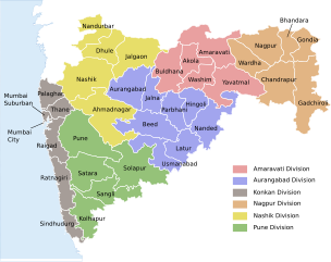
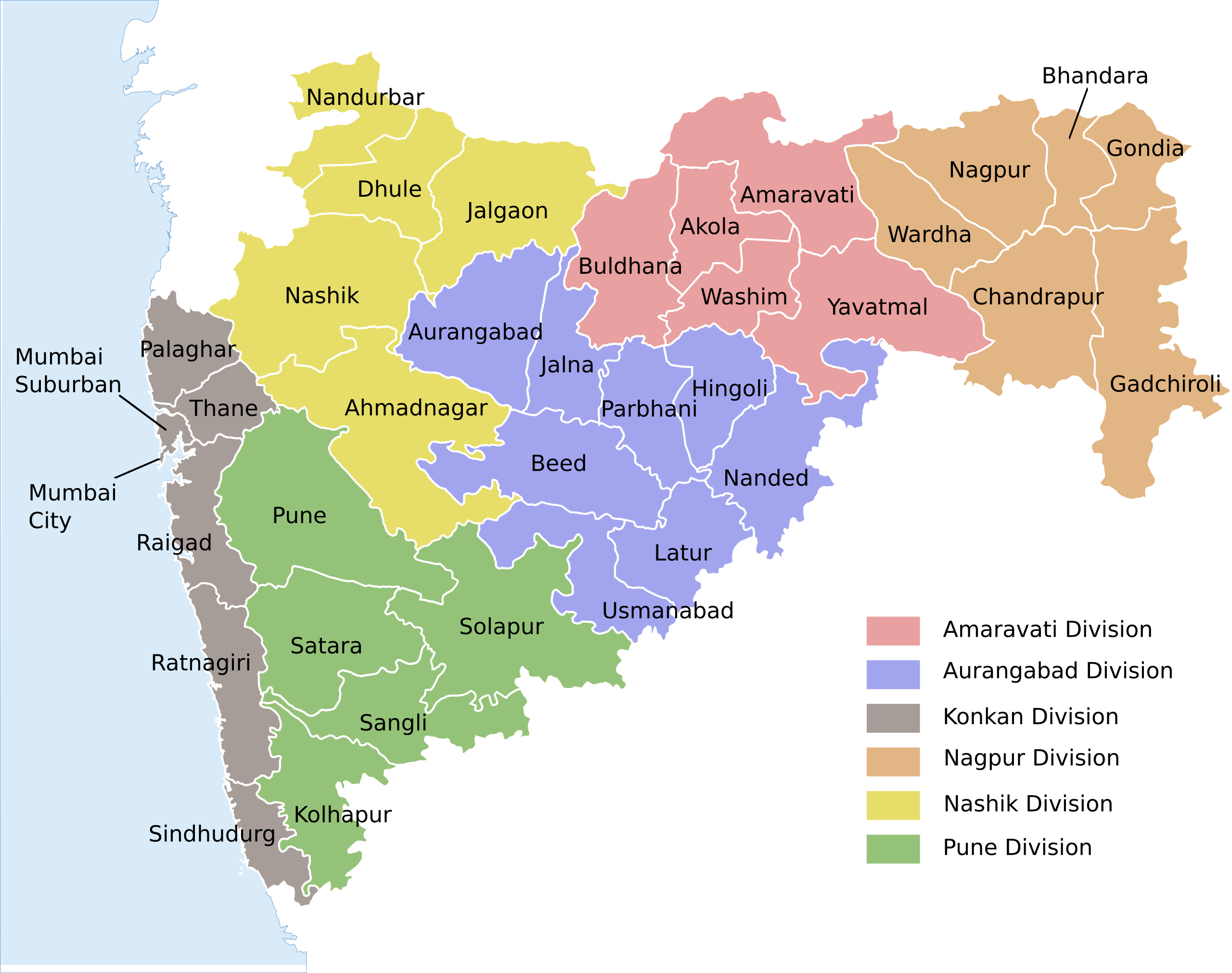
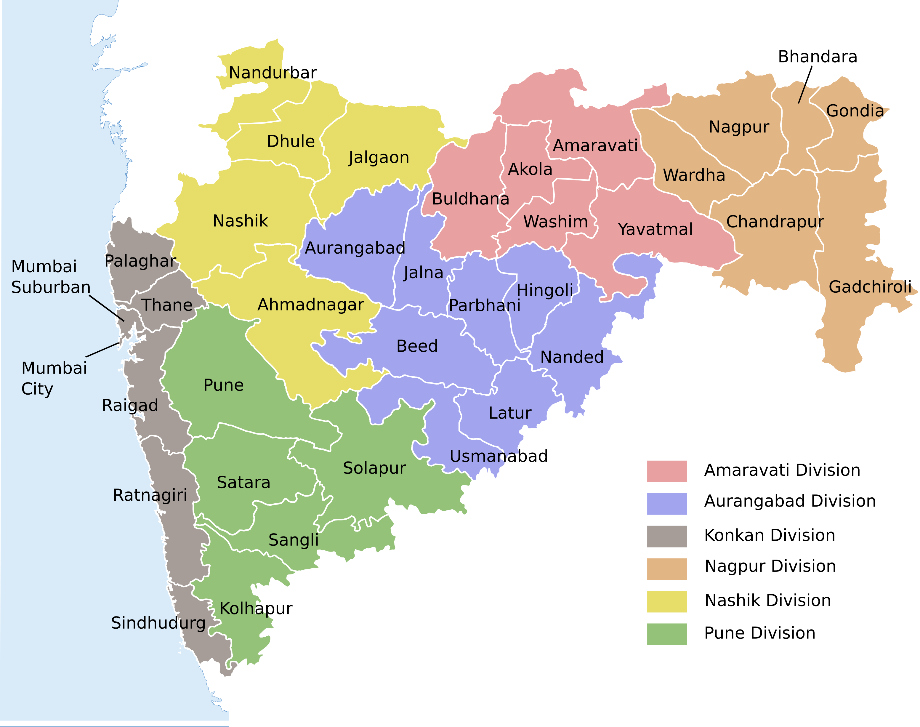
| ವಿವರ | Locator map of the state of en:Maharashtra, India with district boundaries and Admin. divisions |
| ದಿನಾಂಕ | (UTC) |
| ಆಕರ | |
| ಕರ್ತೃ |
|
| ಇತರೆ ಆವೃತ್ತಿಗಳು |
[]
|


| This is a retouched picture, which means that it has been digitally altered from its original version. Modifications: Added colour coding & divisions. The original can be viewed here: Maharashtra locator map.svg:
|
ಈ ಕಡತ ಕ್ರಿಯೇಟಿವ್ ಕಾಮನ್ಸ್ Attribution
-Share Alike 3.0 Unported ಪರವಾನಗಿ ಹೊಂದಿದೆ.
- ನೀವು ಮುಕ್ತ:
- ಹಂಚಿಕೆಗೆ – ಕೆಲಸವನ್ನು ನಕಲು ಮಾಡಲು, ವಿತರಣೆ ಮತ್ತು ಸಾಗಿಸಲು
- ರೀಮಿಕ್ಸ್ ಮಾಡಲು – ಕೆಲಸವನ್ನು ಬಳಸಿಕೊಳ್ಳಲು
- ಈ ಕೆಳಗಿನ ಷರತ್ತುಗಳಲ್ಲಿ:
- ವೈಶಿಷ್ಟ್ಯ – ನೀವು ಸೂಕ್ತವಾದ ಕ್ರೆಡಿಟ್ ನೀಡಬೇಕು, ಪರವಾನಗಿಗೆ ಲಿಂಕ್ ಅನ್ನು ಒದಗಿಸಬೇಕು ಮತ್ತು ಯಾವುದೇ ಬದಲಾವಣೆಗಳನ್ನು ಮಾಡಿದ್ದರೆ ಸೂಚಿಸಬೇಕು. ನೀವು ಯಾವುದೇ ಸಮಂಜಸವಾದ ರೀತಿಯಲ್ಲಿ ಮಾಡಬಹುದು, ಆದರೆ ಪರವಾನಗಿದಾರರು ನಿಮ್ಮನ್ನು ಅಥವಾ ನಿಮ್ಮ ಯಾವುದೇ ಬಳಕೆಯನ್ನು ಅನುಮೋದಿಸಿದಂತೆ ರೀತಿಯಲ್ಲಿ ಉಪಯೋಗಿಸಬಾರದು.
- ಇರುವುದರಂತೆಯೇ ಹಂಚು – ನೀವು ರೀಮಿಕ್ಸ್ ಮಾಡಿದರೆ, ರೂಪಾಂತರಗೊಳಿಸಿದರೆ ಅಥವಾ ವಸ್ತುವಿನ ಮೇಲೆ ನಿರ್ಮಿಸಿದರೆ, ನಿಮ್ಮ ಕೊಡುಗೆಗಳನ್ನು ನೀವು ಮೂಲದಂತೆ ಅದೇ ಅಥವಾ ಹೊಂದಾಣಿಕೆಯ ಪರವಾನಗಿ ಅಡಿಯಲ್ಲಿ ವಿತರಿಸಬೇಕು.
Original upload log
This image is a derivative work of the following images:
- File:Maharashtra_locator_map.svg licensed with Cc-by-sa-3.0
- 2008-12-21T12:08:04Z Planemad 2789x2232 (365091 Bytes) {{Information |Description={{en|1=map}} |Source=Own work by uploader |Author=[[User:PlaneMad|PlaneMad]] |Date= |Permission= |other_versions= }}
Uploaded with derivativeFX
ಕಡತದ ಇತಿಹಾಸ
ದಿನ/ಕಾಲ ಒತ್ತಿದರೆ ಆ ಸಮಯದಲ್ಲಿ ಈ ಕಡತದ ವಸ್ತುಸ್ಥಿತಿ ತೋರುತ್ತದೆ.
| ದಿನ/ಕಾಲ | ಕಿರುನೋಟ | ಆಯಾಮಗಳು | ಬಳಕೆದಾರ | ಟಿಪ್ಪಣಿ | |
|---|---|---|---|---|---|
| ಪ್ರಸಕ್ತ | ೧೦:೨೪, ೧೫ ಆಗಸ್ಟ್ ೨೦೨೦ | | ೩,೧೦೬ × ೨,೪೫೩ (೨೮೯ KB) | শরদিন্দু ভট্টাচার্য্য | File uploaded using svgtranslate tool (https://svgtranslate.toolforge.org/). Added translation for bn. |
| ೦೮:೧೦, ೩ ಆಗಸ್ಟ್ ೨೦೨೦ |  | ೩,೧೦೬ × ೨,೪೫೩ (೨೬೨ KB) | C1MM | Added Palaghar | |
| ೨೧:೩೯, ೧೮ ಆಗಸ್ಟ್ ೨೦೧೧ |  | ೩,೧೦೬ × ೨,೪೫೩ (೨೪೮ KB) | Kaajawa | {{Information |Description=Locator map of the state of en:Maharashtra, India with district boundaries and Admin. divisions |Source=*File:Maharashtra_locator_map.svg |Date=2011-08-18 16:06 (UTC) |Author=*[[:File:Maharashtra_locator_m |
ಕಡತ ಬಳಕೆ
ಈ ಕೆಳಗಿನ ಪುಟವು ಈ ಚಿತ್ರಕ್ಕೆ ಸಂಪರ್ಕ ಹೊಂದಿದೆ:
ಜಾಗತಿಕ ಕಡತ ಉಪಯೋಗ
ಈ ಕಡತವನ್ನು ಕೆಳಗಿನ ಬೇರೆ ವಿಕಿಗಳೂ ಉಪಯೋಗಿಸುತ್ತಿವೆ:
- awa.wikipedia.org ಮೇಲೆ ಬಳಕೆ
- bh.wikipedia.org ಮೇಲೆ ಬಳಕೆ
- bn.wikipedia.org ಮೇಲೆ ಬಳಕೆ
- de.wikipedia.org ಮೇಲೆ ಬಳಕೆ
- dty.wikipedia.org ಮೇಲೆ ಬಳಕೆ
- en.wikipedia.org ಮೇಲೆ ಬಳಕೆ
- eu.wikipedia.org ಮೇಲೆ ಬಳಕೆ
- fi.wikipedia.org ಮೇಲೆ ಬಳಕೆ
- fr.wikipedia.org ಮೇಲೆ ಬಳಕೆ
- ha.wikipedia.org ಮೇಲೆ ಬಳಕೆ
- hi.wikipedia.org ಮೇಲೆ ಬಳಕೆ
- मुम्बई
- महाराष्ट्र
- पुणे
- नागपुर
- माथेरान
- मराठी भाषा
- विदर्भ
- अकोला
- नाशिक
- वर्धा
- अमरावती
- ठाणे
- जुन्नर तालुका
- जलगाँव
- अहमदनगर जिला
- अकोला जिला
- औरंगाबाद जिला, महाराष्ट्र
- अमरावती जिला
- बीड जिला
- भंडारा जिला
- बुलढाणा जिला
- चंद्रपुर जिला
- जालना जिला
- हिंगोली जिला
- गोंदिया जिला
- गढ़चिरौली जिला
- धुले जिला
- रायगढ़ जिला, महाराष्ट्र
- पुणे जिला
- परभणी जिला
- उस्मानाबाद जिला
- नाशिक जिला
- नंदुरबार जिला
ಈ ಫೈಲ್ನ ಹೆಚ್ಚು ಜಾಗತಿಕ ಬಳಕೆಯನ್ನು ವೀಕ್ಷಿಸಿ.