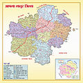
ಚಿತ್ರ:Latur District political map.jpg

ಈ ಮುನ್ನೋಟ ಗಾತ್ರ:೬೦೦ × ೬೦೦ ಪಿಕ್ಸೆಲ್ಗಳು. ಇತರ ರೆಸಲ್ಯೂಶನ್ಗಳು: ೨೪೦ × ೨೪೦ ಪಿಕ್ಸೆಲ್ಗಳು | ೪೮೦ × ೪೮೦ ಪಿಕ್ಸೆಲ್ಗಳು | ೭೬೮ × ೭೬೮ ಪಿಕ್ಸೆಲ್ಗಳು | ೧,೦೨೪ × ೧,೦೨೪ ಪಿಕ್ಸೆಲ್ಗಳು | ೧,೫೨೪ × ೧,೫೨೪ ಪಿಕ್ಸೆಲ್ಗಳು.
ಮೂಲ ಕಡತ (೧,೫೨೪ × ೧,೫೨೪ ಚಿತ್ರಬಿಂದು, ಫೈಲಿನ ಗಾತ್ರ: ೧.೩೬ MB, MIME ಪ್ರಕಾರ: image/jpeg)
ಕಡತದ ಇತಿಹಾಸ
ದಿನ/ಕಾಲ ಒತ್ತಿದರೆ ಆ ಸಮಯದಲ್ಲಿ ಈ ಕಡತದ ವಸ್ತುಸ್ಥಿತಿ ತೋರುತ್ತದೆ.
| ದಿನ/ಕಾಲ | ಕಿರುನೋಟ | ಆಯಾಮಗಳು | ಬಳಕೆದಾರ | ಟಿಪ್ಪಣಿ | |
|---|---|---|---|---|---|
| ಪ್ರಸಕ್ತ | ೧೭:೫೭, ೧೬ ಜುಲೈ ೨೦೧೨ |  | ೧,೫೨೪ × ೧,೫೨೪ (೧.೩೬ MB) | Woodoome | {{subst:Upload marker added by en.wp UW}} {{Information |Description = {{en|Latur District political map}} |Source = http://zplatur.gov.in/htmldocs/leftframe/LaturMap.html |Author = zplatur |Permission = http://zplatur.gov.in/htmldocs/leftframe/LaturMa... |
ಕಡತ ಬಳಕೆ
ಈ ಕೆಳಗಿನ ಪುಟವು ಈ ಚಿತ್ರಕ್ಕೆ ಸಂಪರ್ಕ ಹೊಂದಿದೆ:
ಜಾಗತಿಕ ಕಡತ ಉಪಯೋಗ
ಈ ಕಡತವನ್ನು ಕೆಳಗಿನ ಬೇರೆ ವಿಕಿಗಳೂ ಉಪಯೋಗಿಸುತ್ತಿವೆ:
- en.wikipedia.org ಮೇಲೆ ಬಳಕೆ
- mr.wikipedia.org ಮೇಲೆ ಬಳಕೆ
- te.wikipedia.org ಮೇಲೆ ಬಳಕೆ
