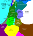
ಚಿತ್ರ:Kingdoms of Israel and Judah map 830.svg

Page contents not supported in other languages.
ವಿಕಿಪೀಡಿಯದಿಂದ, ಇದು ಮುಕ್ತ ಹಾಗೂ ಸ್ವತಂತ್ರ ವಿಶ್ವಕೋಶ

ಮೂಲ ಕಡತ(SVG ಫೈಲು, ಸುಮಾರಾಗಿ ೭೨೦ × ೮೫೯ ಚಿತ್ರಬಿಂದುಗಳು, ಫೈಲಿನ ಗಾತ್ರ: ೯೬ KB)

Render this image in .
ವಿವರ
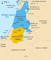
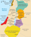
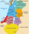
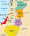
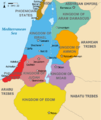
English: Approximate map showing the Kingdoms of Israel (blue) and Judah (orange), ancient Southern Levant borders and ancient cities such as Urmomium and Jerash. The map shows the region in the 9th century BCE.
Italiano: Il regno di Giuda e quello di Israele nell'età del ferro (VIII secolo a.C.).
日本語: 紀元前830年代のユダ王国(黄色).
Русский: Царство Иудея 927 по 526 гг. до н. э. Отсюда иудеи были сосланы завоевателями в Вавилонский регион.
Bahasa Indonesia: Peta kerajaan-kerajaan di daerah tersebut pada abad 9 SM.
Simple English: The northern Kingdom of Israel and the Kingdom of Judah to the south.
Srpskohrvatski / српскохрватски: Karta Sjevernog i JUžnog Kraljevstva. Samarija je bila glavni grad Kraljevstva Izrael (plavo). 830-e pne.,.
Latviešu: Izraēlas un Jūdejas karalistes. Jūdejas karaliste (dzeltenā) ap 830. gadu p.m.ē.
ದಿನಾಂಕ (UTC)
ಆಕರ http://www.jewishvirtuallibrary.org/map-of-israel-and-judah-733-bce
ಕರ್ತೃ
ಇತರೆ ಆವೃತ್ತಿಗಳು

[ಸಂಪಾದಿಸಿ]

Color scheme 1
Color scheme 2
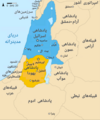
Israel and Judah colored
Just Israel and Judah
I, the copyright holder of this work, hereby publish it under the following licenses:
w:en:Creative Commons
ವೈಶಿಷ್ಟ್ಯ ಇರುವುದರಂತೆಯೇ ಹಂಚು
ಈ ಕಡತ ಕ್ರಿಯೇಟಿವ್ ಕಾಮನ್ಸ್ Attribution -Share Alike 3.0 Unported ಪರವಾನಗಿ ಹೊಂದಿದೆ.
ನೀವು ಮುಕ್ತ:
  • ಹಂಚಿಕೆಗೆ – ಕೆಲಸವನ್ನು ನಕಲು ಮಾಡಲು, ವಿತರಣೆ ಮತ್ತು ಸಾಗಿಸಲು
  • ರೀಮಿಕ್ಸ್ ಮಾಡಲು – ಕೆಲಸವನ್ನು ಬಳಸಿಕೊಳ್ಳಲು
ಈ ಕೆಳಗಿನ ಷರತ್ತುಗಳಲ್ಲಿ:
  • ವೈಶಿಷ್ಟ್ಯ – ನೀವು ಸೂಕ್ತವಾದ ಕ್ರೆಡಿಟ್ ನೀಡಬೇಕು, ಪರವಾನಗಿಗೆ ಲಿಂಕ್ ಅನ್ನು ಒದಗಿಸಬೇಕು ಮತ್ತು ಯಾವುದೇ ಬದಲಾವಣೆಗಳನ್ನು ಮಾಡಿದ್ದರೆ ಸೂಚಿಸಬೇಕು. ನೀವು ಯಾವುದೇ ಸಮಂಜಸವಾದ ರೀತಿಯಲ್ಲಿ ಮಾಡಬಹುದು, ಆದರೆ ಪರವಾನಗಿದಾರರು ನಿಮ್ಮನ್ನು ಅಥವಾ ನಿಮ್ಮ ಯಾವುದೇ ಬಳಕೆಯನ್ನು ಅನುಮೋದಿಸಿದಂತೆ ರೀತಿಯಲ್ಲಿ ಉಪಯೋಗಿಸಬಾರದು.
  • ಇರುವುದರಂತೆಯೇ ಹಂಚು – ನೀವು ರೀಮಿಕ್ಸ್ ಮಾಡಿದರೆ, ರೂಪಾಂತರಗೊಳಿಸಿದರೆ ಅಥವಾ ವಸ್ತುವಿನ ಮೇಲೆ ನಿರ್ಮಿಸಿದರೆ, ನಿಮ್ಮ ಕೊಡುಗೆಗಳನ್ನು ನೀವು ಮೂಲದಂತೆ ಅದೇ ಅಥವಾ ಹೊಂದಾಣಿಕೆಯ ಪರವಾನಗಿ ಅಡಿಯಲ್ಲಿ ವಿತರಿಸಬೇಕು.
GNU head GNU ಉಚಿತ ಡಾಕ್ಯುಮೆಂಟೇಶನ್ ಪರವಾನಗಿ, ಆವೃತ್ತಿಯ ನಿಯಮಗಳ ಅಡಿಯಲ್ಲಿ ಈ ಡಾಕ್ಯುಮೆಂಟ್ ಅನ್ನು ನಕಲಿಸಲು, ವಿತರಿಸಲು ಮತ್ತು/ಅಥವಾ ಮಾರ್ಪಡಿಸಲು ಅನುಮತಿಯನ್ನು ನೀಡಲಾಗಿದೆ. 1.2 ಅಥವಾ ಯಾವುದೇ ನಂತರದ ಆವೃತ್ತಿಯನ್ನು ಉಚಿತ ಸಾಫ್ಟ್‌ವೇರ್ ಫೌಂಡೇಶನ್ ಪ್ರಕಟಿಸಿದೆ; ಯಾವುದೇ ಅಸ್ಥಿರ ವಿಭಾಗಗಳಿಲ್ಲದೆ, ಮುಖ ಪಠ್ಯಗಳಿಲ್ಲ ಮತ್ತು ಹಿಂದಿನ ಕವರ್ ಪಠ್ಯಗಳಿಲ್ಲ. ಪರವಾನಗಿಯ ಪ್ರತಿಯನ್ನು GNU ಉಚಿತ ಡಾಕ್ಯುಮೆಂಟೇಶನ್ ಪರವಾನಗಿ ಎಂಬ ವಿಭಾಗದಲ್ಲಿ ಸೇರಿಸಲಾಗಿದೆ.
ನಿಮ್ಮಿಚ್ಛೆಯ ಪರವಾನಗಿಯನ್ನು ನೀವು ಆರಿಸಿಕೊಳ್ಳಬಹುದು.

Original upload log

This image is a derivative work of the following images:

  • File:Oldtidens_Israel_&_Judea.svg licensed with Cc-by-sa-3.0, GFDL
    • 2010-01-30T16:10:36Z FinnWikiNo 726x868 (109641 Bytes) {{Information |Description={{en|1=Map showing the ancient levant borders and ancient cities such as [[Urmomium]] and [[Jerash]]. The map also shows the region in the 9th century BCE. Notice the coastal land of Philistia, from

Uploaded with derivativeFX

Captions

Add a one-line explanation of what this file represents

Items portrayed in this file

depicts ಇಂಗ್ಲಿಷ್

copyright status ಇಂಗ್ಲಿಷ್

copyrighted ಇಂಗ್ಲಿಷ್

೧೨ ಜುಲೈ 2010

MIME type ಇಂಗ್ಲಿಷ್

image/svg+xml

ಕಡತದ ಇತಿಹಾಸ

ದಿನ/ಕಾಲ ಒತ್ತಿದರೆ ಆ ಸಮಯದಲ್ಲಿ ಈ ಕಡತದ ವಸ್ತುಸ್ಥಿತಿ ತೋರುತ್ತದೆ.

ದಿನ/ಕಾಲಕಿರುನೋಟಆಯಾಮಗಳುಬಳಕೆದಾರಟಿಪ್ಪಣಿ
ಪ್ರಸಕ್ತ೧೯:೪೨, ೧ ಅಕ್ಟೋಬರ್ ೨೦೨೧೧೯:೪೨, ೧ ಅಕ್ಟೋಬರ್ ೨೦೨೧ ವರೆಗಿನ ಆವೃತ್ತಿಯ ಕಿರುನೋಟ೭೨೦ × ೮೫೯ (೯೬ KB)SadopaulFile uploaded using svgtranslate tool (https://svgtranslate.toolforge.org/). Added translation for ko.
೨೧:೨೦, ೧೦ ಫೆಬ್ರವರಿ ೨೦೧೭೨೧:೨೦, ೧೦ ಫೆಬ್ರವರಿ ೨೦೧೭ ವರೆಗಿನ ಆವೃತ್ತಿಯ ಕಿರುನೋಟ೭೨೦ × ೮೫೯ (೮೦ KB)Malus Catulusremoved 'Sizu' - a weird artifact from the Norse original
೦೫:೧೮, ೧೩ ಫೆಬ್ರವರಿ ೨೦೧೧೦೫:೧೮, ೧೩ ಫೆಬ್ರವರಿ ೨೦೧೧ ವರೆಗಿನ ಆವೃತ್ತಿಯ ಕಿರುನೋಟ೭೨೦ × ೮೫೯ (೭೮ KB)Malus Catulus-
೧೬:೫೯, ೧೩ ಜುಲೈ ೨೦೧೦೧೬:೫೯, ೧೩ ಜುಲೈ ೨೦೧೦ ವರೆಗಿನ ಆವೃತ್ತಿಯ ಕಿರುನೋಟ೭೨೦ × ೮೫೯ (೭೯ KB)Malus CatulusFixed Judah color
೧೬:೨೧, ೧೩ ಜುಲೈ ೨೦೧೦೧೬:೨೧, ೧೩ ಜುಲೈ ೨೦೧೦ ವರೆಗಿನ ಆವೃತ್ತಿಯ ಕಿರುನೋಟ೭೨೦ × ೮೫೯ (೭೯ KB)Malus CatulusAdded colors for the two kingdoms and converted their text to path and arial
೦೫:೨೩, ೧೩ ಜುಲೈ ೨೦೧೦೦೫:೨೩, ೧೩ ಜುಲೈ ೨೦೧೦ ವರೆಗಿನ ಆವೃತ್ತಿಯ ಕಿರುನೋಟ೭೨೦ × ೮೫೯ (೬೨ KB)Malus CatulusShrinked down the borders
೦೧:೧೩, ೧೩ ಜುಲೈ ೨೦೧೦೦೧:೧೩, ೧೩ ಜುಲೈ ೨೦೧೦ ವರೆಗಿನ ಆವೃತ್ತಿಯ ಕಿರುನೋಟ೭೨೦ × ೮೫೯ (೬೨ KB)Malus Catulus{{Information |Description={{en|1=Map showing the ancient levant borders and ancient cities such as Urmomium and Jerash. The map also shows the region in the 9th century BCE. Notice the coastal land of Philistia, from which the name "Palestine

ಈ ಕೆಳಗಿನ ಪುಟವು ಈ ಚಿತ್ರಕ್ಕೆ ಸಂಪರ್ಕ ಹೊಂದಿದೆ:

ಜಾಗತಿಕ ಕಡತ ಉಪಯೋಗ

ಈ ಕಡತವನ್ನು ಕೆಳಗಿನ ಬೇರೆ ವಿಕಿಗಳೂ ಉಪಯೋಗಿಸುತ್ತಿವೆ:

ಈ ಫೈಲ್‌ನ ಹೆಚ್ಚು ಜಾಗತಿಕ ಬಳಕೆಯನ್ನು ವೀಕ್ಷಿಸಿ.
ಮೇಲ್ದರ್ಜೆ ಮಾಹಿತಿ