
ಚಿತ್ರ:Durham UK location map.svg

Size of this PNG preview of this SVG file: ೮೦೦ × ೫೨೪ ಪಿಕ್ಸೆಲ್ಗಳು. ಇತರ ರೆಸಲ್ಯೂಶನ್ಗಳು: ೩೨೦ × ೨೧೦ ಪಿಕ್ಸೆಲ್ಗಳು | ೬೪೦ × ೪೧೯ ಪಿಕ್ಸೆಲ್ಗಳು | ೧,೦೨೪ × ೬೭೧ ಪಿಕ್ಸೆಲ್ಗಳು | ೧,೨೮೦ × ೮೩೯ ಪಿಕ್ಸೆಲ್ಗಳು | ೨,೫೬೦ × ೧,೬೭೮ ಪಿಕ್ಸೆಲ್ಗಳು | ೧,೪೨೫ × ೯೩೪ ಪಿಕ್ಸೆಲ್ಗಳು.
ಮೂಲ ಕಡತ (SVG ಫೈಲು, ಸುಮಾರಾಗಿ ೧,೪೨೫ × ೯೩೪ ಚಿತ್ರಬಿಂದುಗಳು, ಫೈಲಿನ ಗಾತ್ರ: ೧.೩೯ MB)
ಈ ಫೈಲು ವಿಕಿಮೀಡಿಯ ಕಾಮನ್ಸ್ನಲ್ಲಿ ಇರುವುದು. ಅಲ್ಲಿನ ವಿವರಣೆ ಪುಟವನ್ನೇ ಕೆಳಗೆ ತೋರಿಸಲಾಗಿದೆ. ಕಾಮನ್ಸ್ ಕೃತಿಸ್ವಾಮ್ಯತೆಯಿಂದ ಮುಕ್ತ ಫೈಲುಗಳ ಒಂದು ಆಗರ. ಅಲ್ಲಿ ನೀವೂ ಸಹಕರಿಸಬಹುದು. |
| ವಿವರ |
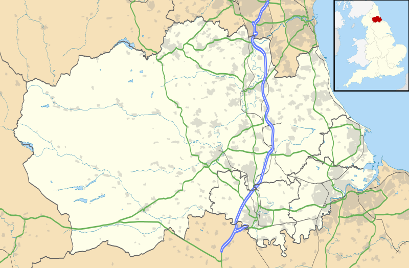
Map of County Durham, UK with the following information shown:
Equirectangular map projection on WGS 84 datum, with N/S stretched 170% Geographic limits:
|
| ದಿನಾಂಕ | |
| ಆಕರ |
|
| ಕರ್ತೃ | Nilfanion, created using Ordnance Survey data |
| ಅನುಮತಿ (ಈ ಕಡತವನ್ನು ಮರುಬಳಕೆ ಮಾಡಲಾಗುತ್ತಿದೆ) |
ಈ ಕಡತ ಕ್ರಿಯೇಟಿವ್ ಕಾಮನ್ಸ್ Attribution
-Share Alike 3.0 Unported ಪರವಾನಗಿ ಹೊಂದಿದೆ. ವೈಶಿಷ್ಟ್ಯ: Contains Ordnance Survey data © Crown copyright and database right
|
| ಇತರೆ ಆವೃತ್ತಿಗಳು | File:Durham UK district map (blank).svg - Blank map |
.svg)
ಕಡತದ ಇತಿಹಾಸ
ದಿನ/ಕಾಲ ಒತ್ತಿದರೆ ಆ ಸಮಯದಲ್ಲಿ ಈ ಕಡತದ ವಸ್ತುಸ್ಥಿತಿ ತೋರುತ್ತದೆ.
| ದಿನ/ಕಾಲ | ಕಿರುನೋಟ | ಆಯಾಮಗಳು | ಬಳಕೆದಾರ | ಟಿಪ್ಪಣಿ | |
|---|---|---|---|---|---|
| ಪ್ರಸಕ್ತ | ೦೦:೩೪, ೨೭ ಸೆಪ್ಟೆಂಬರ್ ೨೦೧೦ | | ೧,೪೨೫ × ೯೩೪ (೧.೩೯ MB) | Nilfanion | fixing dodgy layer |
| ೦೦:೧೩, ೨೭ ಸೆಪ್ಟೆಂಬರ್ ೨೦೧೦ |  | ೧,೪೨೫ × ೯೩೪ (೧.೩೯ MB) | Nilfanion | {{Information |Description=Map of County Durham, UK with the following information shown: *Administrative borders *Coastline, lakes and rivers *Roads and railways *Urban areas Equirectangular map projection on WGS 84 datum, with N/S s |
ಕಡತ ಬಳಕೆ
ಈ ಕೆಳಗಿನ 3 ಪುಟಗಳು ಈ ಚಿತ್ರಕ್ಕೆ ಸಂಪರ್ಕ ಹೊಂದಿವೆ:
ಜಾಗತಿಕ ಕಡತ ಉಪಯೋಗ
ಈ ಕಡತವನ್ನು ಕೆಳಗಿನ ಬೇರೆ ವಿಕಿಗಳೂ ಉಪಯೋಗಿಸುತ್ತಿವೆ:
- ar.wikipedia.org ಮೇಲೆ ಬಳಕೆ
- azb.wikipedia.org ಮೇಲೆ ಬಳಕೆ
- bg.wikipedia.org ಮೇಲೆ ಬಳಕೆ
- ceb.wikipedia.org ಮೇಲೆ ಬಳಕೆ
- en.wikipedia.org ಮೇಲೆ ಬಳಕೆ
- Tanfield, County Durham
- Durham, England
- Barnard Castle
- Darlington
- Willington, County Durham
- Pity Me
- Chester-le-Street
- Hartlepool
- Stockton-on-Tees
- Bishop Auckland
- Seaham
- Sedgefield
- Peterlee
- Annfield Plain
- Easington, County Durham
- Consett
- Newton Aycliffe
- Catchgate
- Norton, County Durham
- Spennymoor
- Beamish Museum
- Stanley, County Durham
- Ferryhill
- Gainford, County Durham
- Billingham
- Eaglescliffe
- Ushaw College
- Lambton Castle
- No Place
- Burnhope
- Craghead
- Shotley Bridge
- Preston Hall, Preston-on-Tees
- Sacriston
- Cassop
- Teesside International Airport
- White-le-Head
- Tanfield Lea
- Quaking Houses
- South Moor
- Oxhill, County Durham
- Preston-on-Tees
- List of places in County Durham
- Lumley Castle
- East Kyo
ಈ ಫೈಲ್ನ ಹೆಚ್ಚು ಜಾಗತಿಕ ಬಳಕೆಯನ್ನು ವೀಕ್ಷಿಸಿ.