
ಚಿತ್ರ:British Empire 1921 IndianSubcontinent.png
ಈ ಮುನ್ನೋಟ ಗಾತ್ರ:೮೦೦ × ೩೫೧ ಪಿಕ್ಸೆಲ್ಗಳು. ಇತರ ರೆಸಲ್ಯೂಶನ್ಗಳು: ೩೨೦ × ೧೪೦ ಪಿಕ್ಸೆಲ್ಗಳು | ೬೪೦ × ೨೮೧ ಪಿಕ್ಸೆಲ್ಗಳು | ೧,೪೨೫ × ೬೨೫ ಪಿಕ್ಸೆಲ್ಗಳು.
ಮೂಲ ಕಡತ (೧,೪೨೫ × ೬೨೫ ಚಿತ್ರಬಿಂದು, ಫೈಲಿನ ಗಾತ್ರ: ೩೯ KB, MIME ಪ್ರಕಾರ: image/png)
ಈ ಫೈಲು ವಿಕಿಮೀಡಿಯ ಕಾಮನ್ಸ್ನಲ್ಲಿ ಇರುವುದು. ಅಲ್ಲಿನ ವಿವರಣೆ ಪುಟವನ್ನೇ ಕೆಳಗೆ ತೋರಿಸಲಾಗಿದೆ. ಕಾಮನ್ಸ್ ಕೃತಿಸ್ವಾಮ್ಯತೆಯಿಂದ ಮುಕ್ತ ಫೈಲುಗಳ ಒಂದು ಆಗರ. ಅಲ್ಲಿ ನೀವೂ ಸಹಕರಿಸಬಹುದು. |
ಸಾರಾಂಶ
| ವಿವರ |
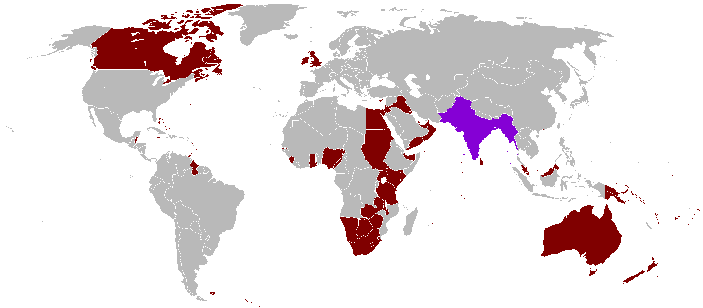
English: A map of the British Empire in 1921 when it was at its height with British India indicated when it too was at its height as well. |
||
| ದಿನಾಂಕ | Uploaded on ಆಗಸ್ಟ್ ೨೭, ೨೦೦೮, 21:41. | ||
| ಆಕರ | ಸ್ವಂತ ಕೆಲಸ | ||
| ಕರ್ತೃ | Vadac. | ||
| ಅನುಮತಿ (ಈ ಕಡತವನ್ನು ಮರುಬಳಕೆ ಮಾಡಲಾಗುತ್ತಿದೆ) |
|
||
| ಇತರೆ ಆವೃತ್ತಿಗಳು | File:British Empire 1921.png, File:British and French empires 1920.png |

|
This historical map image could be re-created using vector graphics as an SVG file. This has several advantages; see Commons:Media for cleanup for more information. If an SVG form of this image is available, please upload it and afterwards replace this template with
{{vector version available|new image name}}.
It is recommended to name the SVG file “British Empire 1921 IndianSubcontinent.svg”—then the template Vector version available (or Vva) does not need the new image name parameter. |
ಕಡತದ ಇತಿಹಾಸ
ದಿನ/ಕಾಲ ಒತ್ತಿದರೆ ಆ ಸಮಯದಲ್ಲಿ ಈ ಕಡತದ ವಸ್ತುಸ್ಥಿತಿ ತೋರುತ್ತದೆ.
| ದಿನ/ಕಾಲ | ಕಿರುನೋಟ | ಆಯಾಮಗಳು | ಬಳಕೆದಾರ | ಟಿಪ್ಪಣಿ | |
|---|---|---|---|---|---|
| ಪ್ರಸಕ್ತ | ೧೩:೨೯, ೩೧ ಅಕ್ಟೋಬರ್ ೨೦೨೧ | | ೧,೪೨೫ × ೬೨೫ (೩೯ KB) | Randomastwritter | . |
| ೦೩:೫೫, ೧೪ ಆಗಸ್ಟ್ ೨೦೧೬ |  | ೧,೪೨೫ × ೬೨೫ (೩೯ KB) | RickoTroanman22 | Tibet re-added | |
| ೦೦:೨೮, ೮ ಮೇ ೨೦೧೧ |  | ೧,೪೨೫ × ೬೨೫ (೫೦ KB) | Quigley | Correct China's borders closer to what was internationally recognized at the time | |
| ೦೭:೧೨, ೧೩ ಅಕ್ಟೋಬರ್ ೨೦೧೦ |  | ೧,೪೨೫ × ೬೨೫ (೫೦ KB) | Vadac | Aden was not part of the British Raj. Matched map to File:British Empire 1921.png | |
| ೨೩:೩೩, ೧೧ ಜನವರಿ ೨೦೦೬ |  | ೧,೩೪೫ × ೬೧೪ (೨೮ KB) | Miljoshi | More Changes as per w:Talk:British Raj. | |
| ೧೫:೫೧, ೯ ಜನವರಿ ೨೦೦೬ |  | ೧,೩೪೫ × ೬೧೪ (೨೮ KB) | Miljoshi | Correcting wrong inclusion of Nicaragua - w:User:Big Adamsky | |
| ೧೭:೨೧, ೬ ಜನವರಿ ೨೦೦೬ |  | ೧,೩೪೫ × ೬೧೪ (೨೨ KB) | Miljoshi | Discounting Sri Lanka | |
| ೧೬:೦೦, ೬ ಜನವರಿ ೨೦೦೬ |  | ೧,೩೪೫ × ೬೧೪ (೨೨ KB) | Miljoshi | Updated map with corrections in Aden, Lebanon, Nicaragua, New Caledonia, Goa, Daman, Pondycherri. | |
| ೨೨:೩೧, ೫ ಜನವರಿ ೨೦೦೬ |  | ೧,೩೪೫ × ೬೧೪ (೨೩ KB) | Miljoshi | British Empire in 1921 - Indian subcontinent is highlighted in purple. Image based on GFDL Image:British Empire 1921.png by w:Arthur Wellesley |
ಕಡತ ಬಳಕೆ
ಈ ಕೆಳಗಿನ ಪುಟವು ಈ ಚಿತ್ರಕ್ಕೆ ಸಂಪರ್ಕ ಹೊಂದಿದೆ:
ಜಾಗತಿಕ ಕಡತ ಉಪಯೋಗ
ಈ ಕಡತವನ್ನು ಕೆಳಗಿನ ಬೇರೆ ವಿಕಿಗಳೂ ಉಪಯೋಗಿಸುತ್ತಿವೆ:
- af.wikipedia.org ಮೇಲೆ ಬಳಕೆ
- bg.wikipedia.org ಮೇಲೆ ಬಳಕೆ
- da.wikipedia.org ಮೇಲೆ ಬಳಕೆ
- de.wikipedia.org ಮೇಲೆ ಬಳಕೆ
- en.wikipedia.org ಮೇಲೆ ಬಳಕೆ
- es.wikipedia.org ಮೇಲೆ ಬಳಕೆ
- hy.wikipedia.org ಮೇಲೆ ಬಳಕೆ
- id.wikipedia.org ಮೇಲೆ ಬಳಕೆ
- kk.wikipedia.org ಮೇಲೆ ಬಳಕೆ
- ml.wikipedia.org ಮೇಲೆ ಬಳಕೆ
- nl.wikipedia.org ಮೇಲೆ ಬಳಕೆ
- nn.wikipedia.org ಮೇಲೆ ಬಳಕೆ
- no.wikipedia.org ಮೇಲೆ ಬಳಕೆ
- ru.wikipedia.org ಮೇಲೆ ಬಳಕೆ
- tum.wikipedia.org ಮೇಲೆ ಬಳಕೆ
- uz.wikipedia.org ಮೇಲೆ ಬಳಕೆ
- vep.wikipedia.org ಮೇಲೆ ಬಳಕೆ