
ಚಿತ್ರ:Armenian Genocide Map-en.svg

Size of this PNG preview of this SVG file: ೮೦೦ × ೩೯೩ ಪಿಕ್ಸೆಲ್ಗಳು. ಇತರ ರೆಸಲ್ಯೂಶನ್ಗಳು: ೩೨೦ × ೧೫೭ ಪಿಕ್ಸೆಲ್ಗಳು | ೬೪೦ × ೩೧೪ ಪಿಕ್ಸೆಲ್ಗಳು | ೧,೦೨೪ × ೫೦೩ ಪಿಕ್ಸೆಲ್ಗಳು | ೧,೨೮೦ × ೬೨೯ ಪಿಕ್ಸೆಲ್ಗಳು | ೨,೫೬೦ × ೧,೨೫೭ ಪಿಕ್ಸೆಲ್ಗಳು | ೨,೫೭೪ × ೧,೨೬೪ ಪಿಕ್ಸೆಲ್ಗಳು.
ಮೂಲ ಕಡತ (SVG ಫೈಲು, ಸುಮಾರಾಗಿ ೨,೫೭೪ × ೧,೨೬೪ ಚಿತ್ರಬಿಂದುಗಳು, ಫೈಲಿನ ಗಾತ್ರ: ೪೬೪ KB)
ಈ ಫೈಲು ವಿಕಿಮೀಡಿಯ ಕಾಮನ್ಸ್ನಲ್ಲಿ ಇರುವುದು. ಅಲ್ಲಿನ ವಿವರಣೆ ಪುಟವನ್ನೇ ಕೆಳಗೆ ತೋರಿಸಲಾಗಿದೆ. ಕಾಮನ್ಸ್ ಕೃತಿಸ್ವಾಮ್ಯತೆಯಿಂದ ಮುಕ್ತ ಫೈಲುಗಳ ಒಂದು ಆಗರ. ಅಲ್ಲಿ ನೀವೂ ಸಹಕರಿಸಬಹುದು. |
ಸಾರಾಂಶ
| ವಿವರ |
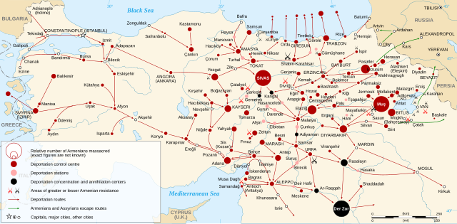
English: Map of the Armenian Genocide in 1915.
Español: Mapa del genocidio armenio en 1915. Français : Carte en anglais du génocide arménien de 1915. Русский: Карта геноцида армян 1915 года. |
| ದಿನಾಂಕ | |
| ಆಕರ |
Other data :
|
| ಕರ್ತೃ | Sémhur |
| ಇತರೆ ಆವೃತ್ತಿಗಳು |
[]
|
| SVG genesis |


| Camera location | | View this and other nearby images on: OpenStreetMap |
|---|
Assessment
|
ಪರವಾನಗಿ
I, the copyright holder of this work, hereby publish it under the following licenses:

|
GNU ಉಚಿತ ಡಾಕ್ಯುಮೆಂಟೇಶನ್ ಪರವಾನಗಿ, ಆವೃತ್ತಿಯ ನಿಯಮಗಳ ಅಡಿಯಲ್ಲಿ ಈ ಡಾಕ್ಯುಮೆಂಟ್ ಅನ್ನು ನಕಲಿಸಲು, ವಿತರಿಸಲು ಮತ್ತು/ಅಥವಾ ಮಾರ್ಪಡಿಸಲು ಅನುಮತಿಯನ್ನು ನೀಡಲಾಗಿದೆ. 1.2 ಅಥವಾ ಯಾವುದೇ ನಂತರದ ಆವೃತ್ತಿಯನ್ನು ಉಚಿತ ಸಾಫ್ಟ್ವೇರ್ ಫೌಂಡೇಶನ್ ಪ್ರಕಟಿಸಿದೆ; ಯಾವುದೇ ಅಸ್ಥಿರ ವಿಭಾಗಗಳಿಲ್ಲದೆ, ಮುಖ ಪಠ್ಯಗಳಿಲ್ಲ ಮತ್ತು ಹಿಂದಿನ ಕವರ್ ಪಠ್ಯಗಳಿಲ್ಲ. ಪರವಾನಗಿಯ ಪ್ರತಿಯನ್ನು GNU ಉಚಿತ ಡಾಕ್ಯುಮೆಂಟೇಶನ್ ಪರವಾನಗಿ ಎಂಬ ವಿಭಾಗದಲ್ಲಿ ಸೇರಿಸಲಾಗಿದೆ. |
This file is licensed under the Creative Commons Attribution-Share Alike 3.0 Unported, 2.5 Generic, 2.0 Generic and 1.0 Generic license.
- ನೀವು ಮುಕ್ತ:
- ಹಂಚಿಕೆಗೆ – ಕೆಲಸವನ್ನು ನಕಲು ಮಾಡಲು, ವಿತರಣೆ ಮತ್ತು ಸಾಗಿಸಲು
- ರೀಮಿಕ್ಸ್ ಮಾಡಲು – ಕೆಲಸವನ್ನು ಬಳಸಿಕೊಳ್ಳಲು
- ಈ ಕೆಳಗಿನ ಷರತ್ತುಗಳಲ್ಲಿ:
- ವೈಶಿಷ್ಟ್ಯ – ನೀವು ಸೂಕ್ತವಾದ ಕ್ರೆಡಿಟ್ ನೀಡಬೇಕು, ಪರವಾನಗಿಗೆ ಲಿಂಕ್ ಅನ್ನು ಒದಗಿಸಬೇಕು ಮತ್ತು ಯಾವುದೇ ಬದಲಾವಣೆಗಳನ್ನು ಮಾಡಿದ್ದರೆ ಸೂಚಿಸಬೇಕು. ನೀವು ಯಾವುದೇ ಸಮಂಜಸವಾದ ರೀತಿಯಲ್ಲಿ ಮಾಡಬಹುದು, ಆದರೆ ಪರವಾನಗಿದಾರರು ನಿಮ್ಮನ್ನು ಅಥವಾ ನಿಮ್ಮ ಯಾವುದೇ ಬಳಕೆಯನ್ನು ಅನುಮೋದಿಸಿದಂತೆ ರೀತಿಯಲ್ಲಿ ಉಪಯೋಗಿಸಬಾರದು.
- ಇರುವುದರಂತೆಯೇ ಹಂಚು – ನೀವು ರೀಮಿಕ್ಸ್ ಮಾಡಿದರೆ, ರೂಪಾಂತರಗೊಳಿಸಿದರೆ ಅಥವಾ ವಸ್ತುವಿನ ಮೇಲೆ ನಿರ್ಮಿಸಿದರೆ, ನಿಮ್ಮ ಕೊಡುಗೆಗಳನ್ನು ನೀವು ಮೂಲದಂತೆ ಅದೇ ಅಥವಾ ಹೊಂದಾಣಿಕೆಯ ಪರವಾನಗಿ ಅಡಿಯಲ್ಲಿ ವಿತರಿಸಬೇಕು.
ನಿಮ್ಮಿಚ್ಛೆಯ ಪರವಾನಗಿಯನ್ನು ನೀವು ಆರಿಸಿಕೊಳ್ಳಬಹುದು.
ಕಡತದ ಇತಿಹಾಸ
ದಿನ/ಕಾಲ ಒತ್ತಿದರೆ ಆ ಸಮಯದಲ್ಲಿ ಈ ಕಡತದ ವಸ್ತುಸ್ಥಿತಿ ತೋರುತ್ತದೆ.
| ದಿನ/ಕಾಲ | ಕಿರುನೋಟ | ಆಯಾಮಗಳು | ಬಳಕೆದಾರ | ಟಿಪ್ಪಣಿ | |
|---|---|---|---|---|---|
| ಪ್ರಸಕ್ತ | ೦೩:೩೭, ೨೫ ಏಪ್ರಿಲ್ ೨೦೨೧ | | ೨,೫೭೪ × ೧,೨೬೪ (೪೬೪ KB) | Pta345MK | Reverted to version as of 22:01, 8 March 2021 (UTC) |
| ೦೩:೩೪, ೨೫ ಏಪ್ರಿಲ್ ೨೦೨೧ |  | ೨,೫೭೪ × ೧,೨೬೪ (೬೨೯ KB) | Pta345MK | File uploaded using svgtranslate tool (https://svgtranslate.toolforge.org/). Added translation for mk. | |
| ೦೩:೦೩, ೨೫ ಏಪ್ರಿಲ್ ೨೦೨೧ |  | ೨,೫೭೪ × ೧,೨೬೪ (೪೬೪ KB) | Pta345MK | Reverted to version as of 22:01, 8 March 2021 (UTC) | |
| ೦೩:೦೧, ೨೫ ಏಪ್ರಿಲ್ ೨೦೨೧ |  | ೨,೫೭೪ × ೧,೨೬೪ (೬೨೯ KB) | Pta345MK | File uploaded using svgtranslate tool (https://svgtranslate.toolforge.org/). Added translation for mk. | |
| ೦೩:೩೧, ೯ ಮಾರ್ಚ್ ೨೦೨೧ |  | ೨,೫೭೪ × ೧,೨೬೪ (೪೬೪ KB) | 4nn1l2 | "ISTANBUL" to "CONSTANTINOPLE (ISTANBUL)" per this // Editing SVG source code using c:User:Rillke/SVGedit.js | |
| ೦೧:೧೮, ೪ ಏಪ್ರಿಲ್ ೨೦೧೧ |  | ೨,೫೭೪ × ೧,೨೬೪ (೪೬೪ KB) | Hayk | fix typo | |
| ೦೧:೦೫, ೪ ಏಪ್ರಿಲ್ ೨೦೧೧ |  | ೨,೫೭೪ × ೧,೨೬೪ (೪೬೪ KB) | Hayk | fix typos | |
| ೨೦:೩೮, ೧೩ ಫೆಬ್ರವರಿ ೨೦೧೧ |  | ೨,೫೭೪ × ೧,೨೬೪ (೫೦೯ KB) | Kathovo | typos, added more town names. | |
| ೦೦:೩೪, ೭ ಫೆಬ್ರವರಿ ೨೦೦೮ |  | ೨,೫೭೪ × ೧,೨೬೪ (೪೮೨ KB) | Sémhur | == Description == {{Information |Description= {{en|Map of the Armenian Genocide in 1915.}} {{fr|Carte en anglais du génocide arménien de 1915.}} |Source=Own work. Sources : * Topographic background |
ಕಡತ ಬಳಕೆ
ಈ ಕೆಳಗಿನ ಪುಟವು ಈ ಚಿತ್ರಕ್ಕೆ ಸಂಪರ್ಕ ಹೊಂದಿದೆ:
ಜಾಗತಿಕ ಕಡತ ಉಪಯೋಗ
ಈ ಕಡತವನ್ನು ಕೆಳಗಿನ ಬೇರೆ ವಿಕಿಗಳೂ ಉಪಯೋಗಿಸುತ್ತಿವೆ:
- an.wikipedia.org ಮೇಲೆ ಬಳಕೆ
- ast.wikipedia.org ಮೇಲೆ ಬಳಕೆ
- bn.wikipedia.org ಮೇಲೆ ಬಳಕೆ
- ca.wikipedia.org ಮೇಲೆ ಬಳಕೆ
- cs.wikipedia.org ಮೇಲೆ ಬಳಕೆ
- el.wikipedia.org ಮೇಲೆ ಬಳಕೆ
- en.wikipedia.org ಮೇಲೆ ಬಳಕೆ
- History of Armenia
- Armenian genocide
- Armenian highlands
- Western Armenia
- Armenian genocide denial
- United Armenia
- Wikipedia:WikiProject Turkey/StatusArticleList
- User talk:Sémhur
- Wikipedia:WikiProject Military history/Showcase
- Wikipedia:WikiProject Military history/Showcase/FP
- Talk:List of massacres in Turkey
- User:Yerevantsi/Western Armenia
- Armenia without Armenians
- Wikipedia:Featured picture candidates/Armenian Genocide
- Wikipedia:WikiProject Military history/News/June 2013/Articles
- Wikipedia:Featured picture candidates/May-2013
- Wikipedia:Wikipedia Signpost/2013-05-13/Featured content
- Wikipedia:Wikipedia Signpost/Single/2013-05-13
- User:Yerevantsi/sandbox/azatagrakan
- Timeline of modern Armenian history
- User talk:EtienneDolet/Archive 2
- Sürgün
- User talk:EtienneDolet/Archive 7
- User:Kevo327
- Talk:Armenian genocide/Archive 27
- User:Amakuru/POTD 14
- User:Amakuru/PotdMainPageSandbox
- User:Amakuru/PotdSandbox
- Template talk:POTD/2019-04-24/Pulled
- Wikipedia:Featured picture candidates/delist/2019
- Wikipedia:Featured picture candidates/delist/Armenian Genocide
- User:Falcaorib
- Wikipedia:WikiProject Military history/Featured content
- Portal:History/Recognized content
- User:Kevo327/Userboxes/Against Denial
- Wikipedia:WikiProject Military history/News/July 2021/Articles
- Wikipedia:WikiProject Former countries/Recognized content
- Wikipedia:WikiProject Turkey/Recognized content
- Wikipedia:WikiProject Armenia/Recognized content
- en.wikiquote.org ಮೇಲೆ ಬಳಕೆ
- en.wikiversity.org ಮೇಲೆ ಬಳಕೆ
- eo.wikipedia.org ಮೇಲೆ ಬಳಕೆ
ಈ ಫೈಲ್ನ ಹೆಚ್ಚು ಜಾಗತಿಕ ಬಳಕೆಯನ್ನು ವೀಕ್ಷಿಸಿ.