
ಚಿತ್ರ:Angola Topography.png

ಈ ಮುನ್ನೋಟ ಗಾತ್ರ:೫೭೦ × ೬೦೦ ಪಿಕ್ಸೆಲ್ಗಳು. ಇತರ ರೆಸಲ್ಯೂಶನ್ಗಳು: ೨೨೮ × ೨೪೦ ಪಿಕ್ಸೆಲ್ಗಳು | ೪೫೬ × ೪೮೦ ಪಿಕ್ಸೆಲ್ಗಳು | ೭೩೦ × ೭೬೮ ಪಿಕ್ಸೆಲ್ಗಳು | ೯೭೩ × ೧,೦೨೪ ಪಿಕ್ಸೆಲ್ಗಳು | ೧,೩೧೮ × ೧,೩೮೭ ಪಿಕ್ಸೆಲ್ಗಳು.
ಮೂಲ ಕಡತ (೧,೩೧೮ × ೧,೩೮೭ ಚಿತ್ರಬಿಂದು, ಫೈಲಿನ ಗಾತ್ರ: ೨.೪೧ MB, MIME ಪ್ರಕಾರ: image/png)
ಈ ಫೈಲು ವಿಕಿಮೀಡಿಯ ಕಾಮನ್ಸ್ನಲ್ಲಿ ಇರುವುದು. ಅಲ್ಲಿನ ವಿವರಣೆ ಪುಟವನ್ನೇ ಕೆಳಗೆ ತೋರಿಸಲಾಗಿದೆ. ಕಾಮನ್ಸ್ ಕೃತಿಸ್ವಾಮ್ಯತೆಯಿಂದ ಮುಕ್ತ ಫೈಲುಗಳ ಒಂದು ಆಗರ. ಅಲ್ಲಿ ನೀವೂ ಸಹಕರಿಸಬಹುದು. |
ಸಾರಾಂಶ
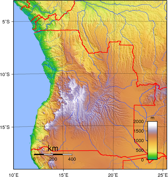
| ವಿವರ | Topographic map of Angola. Created with GMT from public domain GLOBE data. |
| ದಿನಾಂಕ | |
| ಆಕರ | ಸ್ವಂತ ಕೆಲಸ |
| ಕರ್ತೃ | Sadalmelik |
ಪರವಾನಗಿ
| This work has been released into the public domain by its author, I, Sadalmelik. This applies worldwide. In some countries this may not be legally possible; if so: I, Sadalmelik grants anyone the right to use this work for any purpose, without any conditions, unless such conditions are required by law. |
ಕಡತದ ಇತಿಹಾಸ
ದಿನ/ಕಾಲ ಒತ್ತಿದರೆ ಆ ಸಮಯದಲ್ಲಿ ಈ ಕಡತದ ವಸ್ತುಸ್ಥಿತಿ ತೋರುತ್ತದೆ.
| ದಿನ/ಕಾಲ | ಕಿರುನೋಟ | ಆಯಾಮಗಳು | ಬಳಕೆದಾರ | ಟಿಪ್ಪಣಿ | |
|---|---|---|---|---|---|
| ಪ್ರಸಕ್ತ | ೦೦:೨೮, ೩೦ ಜೂನ್ ೨೦೦೭ | | ೧,೩೧೮ × ೧,೩೮೭ (೨.೪೧ MB) | Sadalmelik | better data/colours |
| ೦೩:೧೬, ೨೨ ಜೂನ್ ೨೦೦೭ |  | ೧,೩೧೩ × ೧,೩೮೭ (೨.೦೮ MB) | Sadalmelik | {{Information |Description=Topographic map of Angola. Created with GMT from public domain GLOBE data. |Source=self-made |Date=June 21, 2007 |Author= Sadalmelik }} Category:Maps of Angola Category:Topographic maps of Africa |
ಕಡತ ಬಳಕೆ
ಈ ಕೆಳಗಿನ ಪುಟವು ಈ ಚಿತ್ರಕ್ಕೆ ಸಂಪರ್ಕ ಹೊಂದಿದೆ:
ಜಾಗತಿಕ ಕಡತ ಉಪಯೋಗ
ಈ ಕಡತವನ್ನು ಕೆಳಗಿನ ಬೇರೆ ವಿಕಿಗಳೂ ಉಪಯೋಗಿಸುತ್ತಿವೆ:
- af.wikipedia.org ಮೇಲೆ ಬಳಕೆ
- ast.wikipedia.org ಮೇಲೆ ಬಳಕೆ
- bg.wikipedia.org ಮೇಲೆ ಬಳಕೆ
- bn.wikipedia.org ಮೇಲೆ ಬಳಕೆ
- ca.wikipedia.org ಮೇಲೆ ಬಳಕೆ
- da.wikipedia.org ಮೇಲೆ ಬಳಕೆ
- el.wikipedia.org ಮೇಲೆ ಬಳಕೆ
- en.wikipedia.org ಮೇಲೆ ಬಳಕೆ
- eo.wikipedia.org ಮೇಲೆ ಬಳಕೆ
- es.wikipedia.org ಮೇಲೆ ಬಳಕೆ
- et.wikipedia.org ಮೇಲೆ ಬಳಕೆ
- fa.wikipedia.org ಮೇಲೆ ಬಳಕೆ
- haw.wikipedia.org ಮೇಲೆ ಬಳಕೆ
- hu.wikipedia.org ಮೇಲೆ ಬಳಕೆ
- id.wikipedia.org ಮೇಲೆ ಬಳಕೆ
- ig.wikipedia.org ಮೇಲೆ ಬಳಕೆ
- io.wikipedia.org ಮೇಲೆ ಬಳಕೆ
- it.wikipedia.org ಮೇಲೆ ಬಳಕೆ
- ja.wikipedia.org ಮೇಲೆ ಬಳಕೆ
- ka.wikipedia.org ಮೇಲೆ ಬಳಕೆ
- lt.wikipedia.org ಮೇಲೆ ಬಳಕೆ
- mdf.wikipedia.org ಮೇಲೆ ಬಳಕೆ
- mzn.wikipedia.org ಮೇಲೆ ಬಳಕೆ
- nn.wikipedia.org ಮೇಲೆ ಬಳಕೆ
- pt.wikipedia.org ಮೇಲೆ ಬಳಕೆ
- ro.wikipedia.org ಮೇಲೆ ಬಳಕೆ
- si.wikipedia.org ಮೇಲೆ ಬಳಕೆ
- sr.wikipedia.org ಮೇಲೆ ಬಳಕೆ
- sv.wikipedia.org ಮೇಲೆ ಬಳಕೆ
- szy.wikipedia.org ಮೇಲೆ ಬಳಕೆ
- trv.wikipedia.org ಮೇಲೆ ಬಳಕೆ
- tum.wikipedia.org ಮೇಲೆ ಬಳಕೆ
- uk.wikipedia.org ಮೇಲೆ ಬಳಕೆ
- vep.wikipedia.org ಮೇಲೆ ಬಳಕೆ
- zh.wikipedia.org ಮೇಲೆ ಬಳಕೆ