
ಚಿತ್ರ:United Kingdom labelled map7.png

ಈ ಮುನ್ನೋಟ ಗಾತ್ರ:೩೫೮ × ೫೯೯ ಪಿಕ್ಸೆಲ್ಗಳು. ಇತರ ರೆಸಲ್ಯೂಶನ್ಗಳು: ೧೪೩ × ೨೪೦ ಪಿಕ್ಸೆಲ್ಗಳು | ೨೮೭ × ೪೮೦ ಪಿಕ್ಸೆಲ್ಗಳು | ೬೪೩ × ೧,೦೭೫ ಪಿಕ್ಸೆಲ್ಗಳು.
ಮೂಲ ಕಡತ (೬೪೩ × ೧,೦೭೫ ಚಿತ್ರಬಿಂದು, ಫೈಲಿನ ಗಾತ್ರ: ೮೬ KB, MIME ಪ್ರಕಾರ: image/png)
ಈ ಫೈಲು ವಿಕಿಮೀಡಿಯ ಕಾಮನ್ಸ್ನಲ್ಲಿ ಇರುವುದು. ಅಲ್ಲಿನ ವಿವರಣೆ ಪುಟವನ್ನೇ ಕೆಳಗೆ ತೋರಿಸಲಾಗಿದೆ. ಕಾಮನ್ಸ್ ಕೃತಿಸ್ವಾಮ್ಯತೆಯಿಂದ ಮುಕ್ತ ಫೈಲುಗಳ ಒಂದು ಆಗರ. ಅಲ್ಲಿ ನೀವೂ ಸಹಕರಿಸಬಹುದು. |

|
File:United Kingdom labelled map7 vector.svg is a vector version of this file. It should be used in place of this PNG file when not inferior.
File:United Kingdom labelled map7.png → File:United Kingdom labelled map7 vector.svg
For more information, see Help:SVG. |
 |
ಸಾರಾಂಶ
| ವಿವರ |
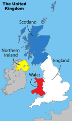
English: Divisions of the United Kingdom |
||
| ದಿನಾಂಕ | ಜುಲೈ ೧೭, ೨೦೦೮ (original upload date) | ||
| ಆಕರ |
ಸ್ವಂತ ಕೆಲಸ by Matt Lewis derived from: File:Uk map home nations.png |
||
| ಕರ್ತೃ | Amended Wikipedia image - amended by Matt Lewis for Wikipedia. | ||
| ಅನುಮತಿ (ಈ ಕಡತವನ್ನು ಮರುಬಳಕೆ ಮಾಡಲಾಗುತ್ತಿದೆ) |
Matt Lewis, the copyright holder of this work, hereby publishes it under the following licenses: ಈ ಕಡತ ಕ್ರಿಯೇಟಿವ್ ಕಾಮನ್ಸ್ Attribution
-Share Alike 3.0 Unported ಪರವಾನಗಿ ಹೊಂದಿದೆ. ವೈಶಿಷ್ಟ್ಯ: Matt Lewis
ನಿಮ್ಮಿಚ್ಛೆಯ ಪರವಾನಗಿಯನ್ನು ನೀವು ಆರಿಸಿಕೊಳ್ಳಬಹುದು. |
||
| ಇತರೆ ಆವೃತ್ತಿಗಳು |
|

Original upload log
The original description page was on en.wikipedia (log). All following user names refer to en.wikipedia.
- 17:17, 1 December 2008 Ddstretch 643×1,075 (86 KB) (Reverted to version as of 02:16, 17 July 2008- colors as used were agreed upon by consensus, and green is clearly too political to stay)
- 16:35, 1 December 2008 Roadnote 643×1,075 (72 KB) (Original by [[User:Matt Lewis|Matt Lewis]] ([[User talk:Matt Lewis|talk]]) - Northern Ireland changed from yellow to green by ~~~~ {{ShouldBeSVG}})
- 02:16, 17 July 2008 Matt Lewis 643×1,075 (86 KB) (Amended Wikipedia image - amended by [[User:Matt Lewis|Matt Lewis]] for Wikipedia.)
ಕಡತದ ಇತಿಹಾಸ
ದಿನ/ಕಾಲ ಒತ್ತಿದರೆ ಆ ಸಮಯದಲ್ಲಿ ಈ ಕಡತದ ವಸ್ತುಸ್ಥಿತಿ ತೋರುತ್ತದೆ.
| ದಿನ/ಕಾಲ | ಕಿರುನೋಟ | ಆಯಾಮಗಳು | ಬಳಕೆದಾರ | ಟಿಪ್ಪಣಿ | |
|---|---|---|---|---|---|
| ಪ್ರಸಕ್ತ | ೦೩:೨೯, ೯ ಡಿಸೆಂಬರ್ ೨೦೧೩ | | ೬೪೩ × ೧,೦೭೫ (೮೬ KB) | Chronus | Reverted to version as of 20:04, 7 December 2013 |
| ೦೧:೩೫, ೮ ಡಿಸೆಂಬರ್ ೨೦೧೩ |  | ೬೪೩ × ೧,೦೭೫ (೫೧೬ KB) | Boonstiffs | Reverted to version as of 20:03, 7 December 2013 | |
| ೦೧:೩೪, ೮ ಡಿಸೆಂಬರ್ ೨೦೧೩ |  | ೬೪೩ × ೧,೦೭೫ (೮೬ KB) | Boonstiffs | Reverted to version as of 05:59, 27 October 2013 | |
| ೦೧:೩೩, ೮ ಡಿಸೆಂಬರ್ ೨೦೧೩ |  | ೬೪೩ × ೧,೦೭೫ (೫೧೬ KB) | Boonstiffs | Reverted to version as of 12:59, 26 October 2013 | |
| ೧೧:೨೯, ೨೭ ಅಕ್ಟೋಬರ್ ೨೦೧೩ |  | ೬೪೩ × ೧,೦೭೫ (೮೬ KB) | Tóraí | Reverted to version as of 11:31, 12 July 2009; map is used on articles relating to the 4 "countries of the United Kingdom", where Cornwall isn't usually considered one | |
| ೧೮:೨೯, ೨೬ ಅಕ್ಟೋಬರ್ ೨೦೧೩ |  | ೬೪೩ × ೧,೦೭೫ (೫೧೬ KB) | Mownberry | Cornwall added. | |
| ೧೭:೦೧, ೧೨ ಜುಲೈ ೨೦೦೯ |  | ೬೪೩ × ೧,೦೭೫ (೮೬ KB) | Chronus | == Summary == {{Information |Description=Divisions of the United Kingdom |Source=originally uploaded to :en at en:File:United Kingdom labelled map7.png |Date= |Author= Amended Wikipedia image - amended by Matt Lewis for Wikipe |
ಕಡತ ಬಳಕೆ
ಈ ಫೈಲನ್ನು ಬಳಸುವ ಯಾವ ಪುಟಗಳೂ ಇಲ್ಲ.
ಜಾಗತಿಕ ಕಡತ ಉಪಯೋಗ
ಈ ಕಡತವನ್ನು ಕೆಳಗಿನ ಬೇರೆ ವಿಕಿಗಳೂ ಉಪಯೋಗಿಸುತ್ತಿವೆ:
- en.wikipedia.org ಮೇಲೆ ಬಳಕೆ