
ಚಿತ್ರ:The Danube Spills into the Black Sea.jpg

ಈ ಮುನ್ನೋಟ ಗಾತ್ರ:೬೬೯ × ೬೦೦ ಪಿಕ್ಸೆಲ್ಗಳು. ಇತರ ರೆಸಲ್ಯೂಶನ್ಗಳು: ೨೬೮ × ೨೪೦ ಪಿಕ್ಸೆಲ್ಗಳು | ೫೩೫ × ೪೮೦ ಪಿಕ್ಸೆಲ್ಗಳು | ೮೫೭ × ೭೬೮ ಪಿಕ್ಸೆಲ್ಗಳು | ೧,೧೪೨ × ೧,೦೨೪ ಪಿಕ್ಸೆಲ್ಗಳು | ೨,೦೮೦ × ೧,೮೬೫ ಪಿಕ್ಸೆಲ್ಗಳು.
ಮೂಲ ಕಡತ (೨,೦೮೦ × ೧,೮೬೫ ಚಿತ್ರಬಿಂದು, ಫೈಲಿನ ಗಾತ್ರ: ೧.೦೭ MB, MIME ಪ್ರಕಾರ: image/jpeg)
ಈ ಫೈಲು ವಿಕಿಮೀಡಿಯ ಕಾಮನ್ಸ್ನಲ್ಲಿ ಇರುವುದು. ಅಲ್ಲಿನ ವಿವರಣೆ ಪುಟವನ್ನೇ ಕೆಳಗೆ ತೋರಿಸಲಾಗಿದೆ. ಕಾಮನ್ಸ್ ಕೃತಿಸ್ವಾಮ್ಯತೆಯಿಂದ ಮುಕ್ತ ಫೈಲುಗಳ ಒಂದು ಆಗರ. ಅಲ್ಲಿ ನೀವೂ ಸಹಕರಿಸಬಹುದು. |
ಸಾರಾಂಶ
| ವಿವರ |
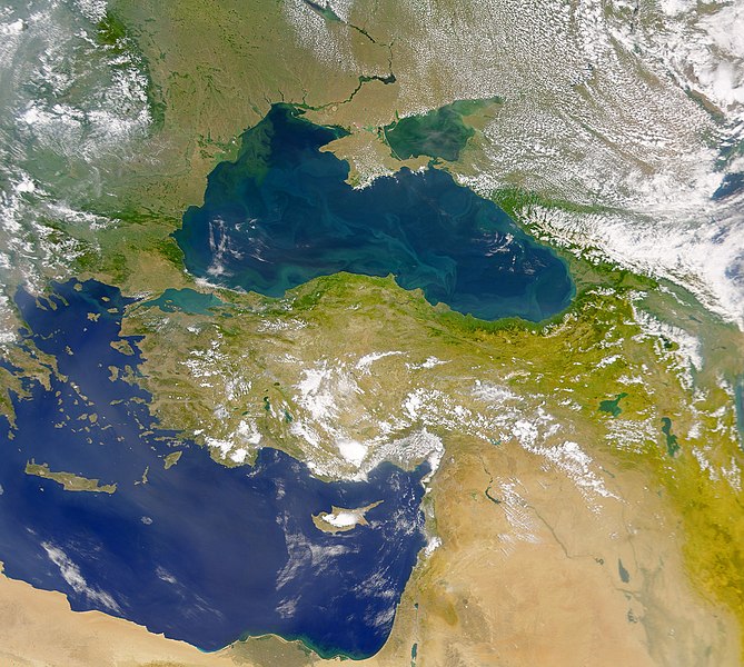
English: This cloud-free Sea-viewing Wide Field-of-view Sensor (SeaWiFS) view of the Black Sea reveals the colourful interplay of currents on the lake’s surface. The green crescent shaped pattern in the north-western corner of the Black Sea is due to the nutrient-rich, sediment-laden discharge of the Danube River stimulating biological activity. The brighter, more turquoise patterns on the lake to the south and east are probably blooms of another type of phytoplankton. |
| ದಿನಾಂಕ | |
| ಆಕರ | NASA Earth Observatory |
| ಕರ್ತೃ | The SeaWiFS Project |
Image courtesy of the NASA/Goddard Space Flight Center, and ORBIMAGE.
ಪರವಾನಗಿ
| This file is in the public domain in the United States because it was solely created by NASA. NASA copyright policy states that "NASA material is not protected by copyright unless noted". (See Template:PD-USGov, NASA copyright policy page or JPL Image Use Policy.) | ||
 |
Warnings:
|
ಕಡತದ ಇತಿಹಾಸ
ದಿನ/ಕಾಲ ಒತ್ತಿದರೆ ಆ ಸಮಯದಲ್ಲಿ ಈ ಕಡತದ ವಸ್ತುಸ್ಥಿತಿ ತೋರುತ್ತದೆ.
| ದಿನ/ಕಾಲ | ಕಿರುನೋಟ | ಆಯಾಮಗಳು | ಬಳಕೆದಾರ | ಟಿಪ್ಪಣಿ | |
|---|---|---|---|---|---|
| ಪ್ರಸಕ್ತ | ೧೬:೫೦, ೨೦ ಏಪ್ರಿಲ್ ೨೦೧೦ | | ೨,೦೮೦ × ೧,೮೬೫ (೧.೦೭ MB) | Originalwana | {{Information |Description={{en|1=This cloud-free Sea-viewing Wide Field-of-view Sensor (SeaWiFS) view of the Black Sea reveals the colourful interplay of currents on the lake’s surface. The green crescent shaped pattern in the north-western cor |
ಕಡತ ಬಳಕೆ
ಈ ಕೆಳಗಿನ 2 ಪುಟಗಳು ಈ ಚಿತ್ರಕ್ಕೆ ಸಂಪರ್ಕ ಹೊಂದಿವೆ:
ಜಾಗತಿಕ ಕಡತ ಉಪಯೋಗ
ಈ ಕಡತವನ್ನು ಕೆಳಗಿನ ಬೇರೆ ವಿಕಿಗಳೂ ಉಪಯೋಗಿಸುತ್ತಿವೆ:
- ady.wikipedia.org ಮೇಲೆ ಬಳಕೆ
- crh.wikipedia.org ಮೇಲೆ ಬಳಕೆ
- en.wikipedia.org ಮೇಲೆ ಬಳಕೆ
- eo.wikipedia.org ಮೇಲೆ ಬಳಕೆ
- fr.wikipedia.org ಮೇಲೆ ಬಳಕೆ
- gu.wikipedia.org ಮೇಲೆ ಬಳಕೆ
- hak.wikipedia.org ಮೇಲೆ ಬಳಕೆ
- hr.wikipedia.org ಮೇಲೆ ಬಳಕೆ
- hu.wikipedia.org ಮೇಲೆ ಬಳಕೆ
- ilo.wikipedia.org ಮೇಲೆ ಬಳಕೆ
- ja.wikipedia.org ಮೇಲೆ ಬಳಕೆ
- lg.wikipedia.org ಮೇಲೆ ಬಳಕೆ
- pl.wikipedia.org ಮೇಲೆ ಬಳಕೆ
- rm.wikipedia.org ಮೇಲೆ ಬಳಕೆ
- sr.wikipedia.org ಮೇಲೆ ಬಳಕೆ
- ta.wikipedia.org ಮೇಲೆ ಬಳಕೆ
- uk.wikipedia.org ಮೇಲೆ ಬಳಕೆ
- vi.wikipedia.org ಮೇಲೆ ಬಳಕೆ
- wuu.wikipedia.org ಮೇಲೆ ಬಳಕೆ
- zh.wikipedia.org ಮೇಲೆ ಬಳಕೆ