
ಚಿತ್ರ:Niger saharan medieval trade routes.PNG
ಈ ಮುನ್ನೋಟ ಗಾತ್ರ:೮೦೦ × ೩೧೯ ಪಿಕ್ಸೆಲ್ಗಳು. ಇತರ ರೆಸಲ್ಯೂಶನ್ಗಳು: ೩೨೦ × ೧೨೮ ಪಿಕ್ಸೆಲ್ಗಳು | ೮೧೭ × ೩೨೬ ಪಿಕ್ಸೆಲ್ಗಳು.
ಮೂಲ ಕಡತ (೮೧೭ × ೩೨೬ ಚಿತ್ರಬಿಂದು, ಫೈಲಿನ ಗಾತ್ರ: ೨೬೩ KB, MIME ಪ್ರಕಾರ: image/png)
ಈ ಫೈಲು ವಿಕಿಮೀಡಿಯ ಕಾಮನ್ಸ್ನಲ್ಲಿ ಇರುವುದು. ಅಲ್ಲಿನ ವಿವರಣೆ ಪುಟವನ್ನೇ ಕೆಳಗೆ ತೋರಿಸಲಾಗಿದೆ. ಕಾಮನ್ಸ್ ಕೃತಿಸ್ವಾಮ್ಯತೆಯಿಂದ ಮುಕ್ತ ಫೈಲುಗಳ ಒಂದು ಆಗರ. ಅಲ್ಲಿ ನೀವೂ ಸಹಕರಿಸಬಹುದು. |
ಸಾರಾಂಶ
| ವಿವರ |
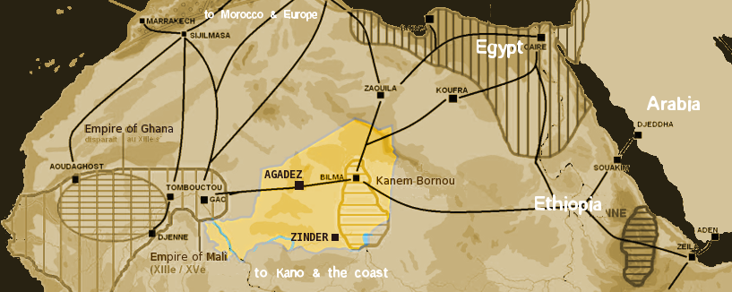
English: Map showing the main trans-Saharan caravan routes circa 1400. Also shown are the Ghana Empire (until the 13th century) and 13th – 15th century Mali Empire. Note the western route running from Djenné via Timbuktu to Sijilmassa. Present day Niger in yellow. Español: Mapa que muestra las principales rutas de caravanas transaharianas alrededor de 1400. También se muestran el Imperio de Ghana (hasta el siglo XIII) y el Imperio de Mali del siglo XIII-XV. Tenga en cuenta la ruta occidental que va desde Djenné a través de Tombuctú a Sijilmassa. En amarillo la extensión del Níger actual. |
| ದಿನಾಂಕ | |
| ಆಕರ | self-made using The Gimp and Image:Africa historical traite.JPG |
| ಕರ್ತೃ | T L Miles |
| ಅನುಮತಿ (ಈ ಕಡತವನ್ನು ಮರುಬಳಕೆ ಮಾಡಲಾಗುತ್ತಿದೆ) |
Public Domain |

|
This map image could be re-created using vector graphics as an SVG file. This has several advantages; see Commons:Media for cleanup for more information. If an SVG form of this image is available, please upload it and afterwards replace this template with
{{vector version available|new image name}}.
It is recommended to name the SVG file “Niger saharan medieval trade routes.svg”—then the template Vector version available (or Vva) does not need the new image name parameter. |
ಪರವಾನಗಿ
| I, the copyright holder of this work, release this work into the public domain. This applies worldwide. In some countries this may not be legally possible; if so: I grant anyone the right to use this work for any purpose, without any conditions, unless such conditions are required by law. |
ಕಡತದ ಇತಿಹಾಸ
ದಿನ/ಕಾಲ ಒತ್ತಿದರೆ ಆ ಸಮಯದಲ್ಲಿ ಈ ಕಡತದ ವಸ್ತುಸ್ಥಿತಿ ತೋರುತ್ತದೆ.
| ದಿನ/ಕಾಲ | ಕಿರುನೋಟ | ಆಯಾಮಗಳು | ಬಳಕೆದಾರ | ಟಿಪ್ಪಣಿ | |
|---|---|---|---|---|---|
| ಪ್ರಸಕ್ತ | ೦೦:೩೯, ೧೯ ಜನವರಿ ೨೦೦೮ | ೮೧೭ × ೩೨೬ (೨೬೩ KB) | T L Miles | {{Information |Description=Map of Medieval Saharan Trade routes, centerd on Niger |Source=self-made using The Gimp and Image:Africa historical traite.JPG |Date=2008-01-18 |Author= T L Miles |Permission=Public Domain |other_versions= } |
ಕಡತ ಬಳಕೆ
ಈ ಕೆಳಗಿನ ಪುಟವು ಈ ಚಿತ್ರಕ್ಕೆ ಸಂಪರ್ಕ ಹೊಂದಿದೆ:
ಜಾಗತಿಕ ಕಡತ ಉಪಯೋಗ
ಈ ಕಡತವನ್ನು ಕೆಳಗಿನ ಬೇರೆ ವಿಕಿಗಳೂ ಉಪಯೋಗಿಸುತ್ತಿವೆ:
- af.wikipedia.org ಮೇಲೆ ಬಳಕೆ
- ar.wikipedia.org ಮೇಲೆ ಬಳಕೆ
- arz.wikipedia.org ಮೇಲೆ ಬಳಕೆ
- ast.wikipedia.org ಮೇಲೆ ಬಳಕೆ
- azb.wikipedia.org ಮೇಲೆ ಬಳಕೆ
- az.wikipedia.org ಮೇಲೆ ಬಳಕೆ
- ba.wikipedia.org ಮೇಲೆ ಬಳಕೆ
- be.wikipedia.org ಮೇಲೆ ಬಳಕೆ
- bn.wikipedia.org ಮೇಲೆ ಬಳಕೆ
- br.wikipedia.org ಮೇಲೆ ಬಳಕೆ
- ca.wikipedia.org ಮೇಲೆ ಬಳಕೆ
- cs.wikipedia.org ಮೇಲೆ ಬಳಕೆ
- de.wikipedia.org ಮೇಲೆ ಬಳಕೆ
- el.wikipedia.org ಮೇಲೆ ಬಳಕೆ
- en.wikipedia.org ಮೇಲೆ ಬಳಕೆ
- en.wikivoyage.org ಮೇಲೆ ಬಳಕೆ
- eo.wikipedia.org ಮೇಲೆ ಬಳಕೆ
- es.wikipedia.org ಮೇಲೆ ಬಳಕೆ
- eu.wikipedia.org ಮೇಲೆ ಬಳಕೆ
- fi.wikipedia.org ಮೇಲೆ ಬಳಕೆ
- fr.wikipedia.org ಮೇಲೆ ಬಳಕೆ
- ga.wikipedia.org ಮೇಲೆ ಬಳಕೆ
- gl.wikipedia.org ಮೇಲೆ ಬಳಕೆ
- gu.wikipedia.org ಮೇಲೆ ಬಳಕೆ
- ha.wikipedia.org ಮೇಲೆ ಬಳಕೆ
- he.wikipedia.org ಮೇಲೆ ಬಳಕೆ
- hr.wikipedia.org ಮೇಲೆ ಬಳಕೆ
- hu.wikipedia.org ಮೇಲೆ ಬಳಕೆ
ಈ ಫೈಲ್ನ ಹೆಚ್ಚು ಜಾಗತಿಕ ಬಳಕೆಯನ್ನು ವೀಕ್ಷಿಸಿ.