
ಚಿತ್ರ:LocationNSAm3.png

ಈ ಮುನ್ನೋಟ ಗಾತ್ರ:೬೦೦ × ೬೦೦ ಪಿಕ್ಸೆಲ್ಗಳು. ಇತರ ರೆಸಲ್ಯೂಶನ್ಗಳು: ೨೪೦ × ೨೪೦ ಪಿಕ್ಸೆಲ್ಗಳು | ೪೮೦ × ೪೮೦ ಪಿಕ್ಸೆಲ್ಗಳು.
ಮೂಲ ಕಡತ (೮೦೦ × ೮೦೦ ಚಿತ್ರಬಿಂದು, ಫೈಲಿನ ಗಾತ್ರ: ೨೨ KB, MIME ಪ್ರಕಾರ: image/png)
ಈ ಫೈಲು ವಿಕಿಮೀಡಿಯ ಕಾಮನ್ಸ್ನಲ್ಲಿ ಇರುವುದು. ಅಲ್ಲಿನ ವಿವರಣೆ ಪುಟವನ್ನೇ ಕೆಳಗೆ ತೋರಿಸಲಾಗಿದೆ. ಕಾಮನ್ಸ್ ಕೃತಿಸ್ವಾಮ್ಯತೆಯಿಂದ ಮುಕ್ತ ಫೈಲುಗಳ ಒಂದು ಆಗರ. ಅಲ್ಲಿ ನೀವೂ ಸಹಕರಿಸಬಹುದು. |
ಸಾರಾಂಶ
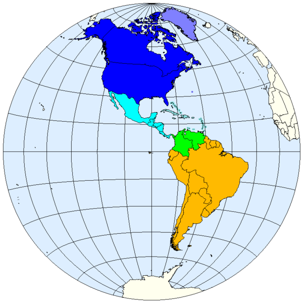
| ವಿವರ | Division of the Americas into North, Middle and South America. |
| ದಿನಾಂಕ | |
| ಆಕರ | prepared from public domain maps created by w:en:User:E Pluribus Anthony. |
| ಕರ್ತೃ | Spacepotato |
Legend
- 0000FF: Northern America.
- 8080FF: Sometimes included in North America.
- 00FFFF: Middle America.
- 8DE1E1: West Indies; often included in Middle America.
- 00FF00: May be included in either Middle or South America.
- FFBA00: South America.
References
- pp. 2–3, World Regional Geography, Lydia Milhelič Pulsipher, Conrad Goodwin, and Alex Pulsipher, New York: W. H. Freeman, 1999 (ISBN 0-7167-3628-4.) Divides the Americas into North America and Middle and South America.
- pp. 30–31, Geography: Realms, Regions, and Concepts, H. J. de Blij and Peter O. Muller, Wiley, 12th ed., 2005 (ISBN 047171786X.) Divides the Americas into North America, Middle America, and South America.
- "Middle America." Merriam-Webster's Online Dictionary. Accessed October 11, 2007. Defines Middle America to include "Mexico, Central America, often the West Indies, and sometimes Colombia and Venezuela."
- "Middle America." Encyclopædia Britannica, on line. Accessed October 10, 2007. Defines Middle America to include Central America, Mexico, and sometimes the Caribbean islands.
- "Middle America." American Heritage Dictionary of the English Language, Fourth Edition, on line. Accessed October 11, 2007. Defines Middle America to include "Mexico, Central America, and sometimes the West Indies."
ಪರವಾನಗಿ
| I, the copyright holder of this work, release this work into the public domain. This applies worldwide. In some countries this may not be legally possible; if so: I grant anyone the right to use this work for any purpose, without any conditions, unless such conditions are required by law. |
See also
- Image:LocationNSAm.png
- Image:LocationNSAm2.png
- Image:LocationNSAngloLatin.png
- Image:LocationNSAmUNGeoscheme.png
ಕಡತದ ಇತಿಹಾಸ
ದಿನ/ಕಾಲ ಒತ್ತಿದರೆ ಆ ಸಮಯದಲ್ಲಿ ಈ ಕಡತದ ವಸ್ತುಸ್ಥಿತಿ ತೋರುತ್ತದೆ.
| ದಿನ/ಕಾಲ | ಕಿರುನೋಟ | ಆಯಾಮಗಳು | ಬಳಕೆದಾರ | ಟಿಪ್ಪಣಿ | |
|---|---|---|---|---|---|
| ಪ್ರಸಕ್ತ | ೦೬:೧೧, ೧೨ ಅಕ್ಟೋಬರ್ ೨೦೦೭ | | ೮೦೦ × ೮೦೦ (೨೨ KB) | Spacepotato | |
| ೦೧:೨೩, ೧೨ ಅಕ್ಟೋಬರ್ ೨೦೦೭ |  | ೮೦೦ × ೭೯೫ (೨೨ KB) | Spacepotato | ||
| ೦೧:೧೦, ೧೨ ಅಕ್ಟೋಬರ್ ೨೦೦೭ |  | ೮೦೦ × ೭೯೫ (೨೨ KB) | Spacepotato | {{Information |Description=Division of the Americas into North, Middle and South America. |Source=prepared from public domain maps created by w:en:User:E Pluribus Anthony. |Date=October 11, 2007. |Author= Spacepotato }} ==Referen |
ಕಡತ ಬಳಕೆ
ಈ ಕೆಳಗಿನ 2 ಪುಟಗಳು ಈ ಚಿತ್ರಕ್ಕೆ ಸಂಪರ್ಕ ಹೊಂದಿವೆ:
ಜಾಗತಿಕ ಕಡತ ಉಪಯೋಗ
ಈ ಕಡತವನ್ನು ಕೆಳಗಿನ ಬೇರೆ ವಿಕಿಗಳೂ ಉಪಯೋಗಿಸುತ್ತಿವೆ:
- ar.wikipedia.org ಮೇಲೆ ಬಳಕೆ
- bn.wikipedia.org ಮೇಲೆ ಬಳಕೆ
- en.wikipedia.org ಮೇಲೆ ಬಳಕೆ
- pt.wikipedia.org ಮೇಲೆ ಬಳಕೆ