
ಚಿತ್ರ:Ladakh locator map.svg

Size of this PNG preview of this SVG file: ೭೬೪ × ೬೦೦ ಪಿಕ್ಸೆಲ್ಗಳು. ಇತರ ರೆಸಲ್ಯೂಶನ್ಗಳು: ೩೦೬ × ೨೪೦ ಪಿಕ್ಸೆಲ್ಗಳು | ೬೧೧ × ೪೮೦ ಪಿಕ್ಸೆಲ್ಗಳು | ೯೭೮ × ೭೬೮ ಪಿಕ್ಸೆಲ್ಗಳು | ೧,೨೮೦ × ೧,೦೦೫ ಪಿಕ್ಸೆಲ್ಗಳು | ೨,೫೬೦ × ೨,೦೧೦ ಪಿಕ್ಸೆಲ್ಗಳು | ೨,೧೬೦ × ೧,೬೯೬ ಪಿಕ್ಸೆಲ್ಗಳು.
ಮೂಲ ಕಡತ (SVG ಫೈಲು, ಸುಮಾರಾಗಿ ೨,೧೬೦ × ೧,೬೯೬ ಚಿತ್ರಬಿಂದುಗಳು, ಫೈಲಿನ ಗಾತ್ರ: ೨೦೨ KB)
ಈ ಫೈಲು ವಿಕಿಮೀಡಿಯ ಕಾಮನ್ಸ್ನಲ್ಲಿ ಇರುವುದು. ಅಲ್ಲಿನ ವಿವರಣೆ ಪುಟವನ್ನೇ ಕೆಳಗೆ ತೋರಿಸಲಾಗಿದೆ. ಕಾಮನ್ಸ್ ಕೃತಿಸ್ವಾಮ್ಯತೆಯಿಂದ ಮುಕ್ತ ಫೈಲುಗಳ ಒಂದು ಆಗರ. ಅಲ್ಲಿ ನೀವೂ ಸಹಕರಿಸಬಹುದು. |
| ಶೀರ್ಷಿಕೆ |
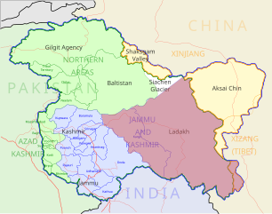
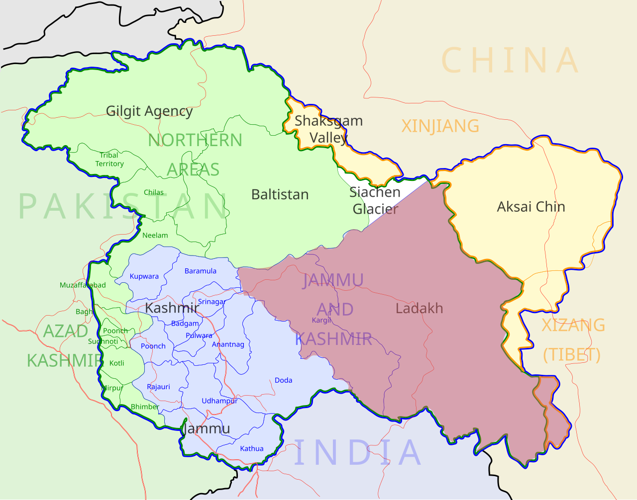
Ladakh locator map |
| Description |
Locator map for the region of w:Ladakh (higlighted in red) in the w:Indian state of w:Jammu and Kashmir |
| ದಿನಾಂಕ | |
| ಆಕರ |
ಸ್ವಂತ ಕೆಲಸ |
| ಸೃಷ್ಟಿಕರ್ತ | |
| ಅನುಮತಿ (ಈ ಕಡತವನ್ನು ಮರುಬಳಕೆ ಮಾಡಲಾಗುತ್ತಿದೆ) |
I, the copyright holder of this work, hereby publish it under the following license: ಈ ಕಡತ ಕ್ರಿಯೇಟಿವ್ ಕಾಮನ್ಸ್ Attribution
-Share Alike 3.0 Unported ಪರವಾನಗಿ ಹೊಂದಿದೆ.
|
| Geotemporal data | |
| Date depicted | second half of 20 century ಮತ್ತು 21 century |
| Georeferencing | If inappropriate please set warp_status = skip to hide. |
| Archival data | |
| Notes | Part of WikiProject India Maps |
ಕಡತದ ಇತಿಹಾಸ
ದಿನ/ಕಾಲ ಒತ್ತಿದರೆ ಆ ಸಮಯದಲ್ಲಿ ಈ ಕಡತದ ವಸ್ತುಸ್ಥಿತಿ ತೋರುತ್ತದೆ.
| ದಿನ/ಕಾಲ | ಕಿರುನೋಟ | ಆಯಾಮಗಳು | ಬಳಕೆದಾರ | ಟಿಪ್ಪಣಿ | |
|---|---|---|---|---|---|
| ಪ್ರಸಕ್ತ | ೧೧:೨೦, ೨ ಡಿಸೆಂಬರ್ ೨೦೧೨ | | ೨,೧೬೦ × ೧,೬೯೬ (೨೦೨ KB) | Baomi | 改“XIJANG”为“XIZANG” |
| ೦೫:೫೪, ೧೦ ಮೇ ೨೦೦೭ |  | ೨,೧೬೦ × ೧,೬೯೬ (೨೬೦ KB) | Saravask | {{WikiProject_India_Maps |Title=Ladakh locator map |Description=Locator map for the region of w:Ladakh (higlighted in red) in the w:Indian state of [w:Jammu and Kashmir]] |Source= [http://www.koausa.org/Nature/maps.html Map of Kashmir], |Date=May |
ಕಡತ ಬಳಕೆ
ಈ ಫೈಲನ್ನು ಬಳಸುವ ಯಾವ ಪುಟಗಳೂ ಇಲ್ಲ.
ಜಾಗತಿಕ ಕಡತ ಉಪಯೋಗ
ಈ ಕಡತವನ್ನು ಕೆಳಗಿನ ಬೇರೆ ವಿಕಿಗಳೂ ಉಪಯೋಗಿಸುತ್ತಿವೆ:
- as.wikipedia.org ಮೇಲೆ ಬಳಕೆ
- awa.wikipedia.org ಮೇಲೆ ಬಳಕೆ
- bpy.wikipedia.org ಮೇಲೆ ಬಳಕೆ
- ceb.wikipedia.org ಮೇಲೆ ಬಳಕೆ
- en.wikipedia.org ಮೇಲೆ ಬಳಕೆ
- fa.wikipedia.org ಮೇಲೆ ಬಳಕೆ
- he.wikipedia.org ಮೇಲೆ ಬಳಕೆ
- hi.wikipedia.org ಮೇಲೆ ಬಳಕೆ
- hu.wikipedia.org ಮೇಲೆ ಬಳಕೆ
- incubator.wikimedia.org ಮೇಲೆ ಬಳಕೆ
- it.wikipedia.org ಮೇಲೆ ಬಳಕೆ
- it.wikivoyage.org ಮೇಲೆ ಬಳಕೆ
- ja.wikipedia.org ಮೇಲೆ ಬಳಕೆ
- ko.wikipedia.org ಮೇಲೆ ಬಳಕೆ
- mai.wikipedia.org ಮೇಲೆ ಬಳಕೆ
- ml.wikipedia.org ಮೇಲೆ ಬಳಕೆ
- nn.wikipedia.org ಮೇಲೆ ಬಳಕೆ
- no.wikipedia.org ಮೇಲೆ ಬಳಕೆ
- or.wikipedia.org ಮೇಲೆ ಬಳಕೆ
- pam.wikipedia.org ಮೇಲೆ ಬಳಕೆ
ಈ ಫೈಲ್ನ ಹೆಚ್ಚು ಜಾಗತಿಕ ಬಳಕೆಯನ್ನು ವೀಕ್ಷಿಸಿ.