
ಚಿತ್ರ:Isle of Jersey (ASTER).jpg

ಈ ಮುನ್ನೋಟ ಗಾತ್ರ:೭೬೩ × ೬೦೦ ಪಿಕ್ಸೆಲ್ಗಳು. ಇತರ ರೆಸಲ್ಯೂಶನ್ಗಳು: ೩೦೬ × ೨೪೦ ಪಿಕ್ಸೆಲ್ಗಳು | ೬೧೧ × ೪೮೦ ಪಿಕ್ಸೆಲ್ಗಳು | ೯೭೮ × ೭೬೮ ಪಿಕ್ಸೆಲ್ಗಳು | ೧,೨೮೦ × ೧,೦೦೬ ಪಿಕ್ಸೆಲ್ಗಳು | ೧,೪೦೦ × ೧,೧೦೦ ಪಿಕ್ಸೆಲ್ಗಳು.
ಮೂಲ ಕಡತ (೧,೪೦೦ × ೧,೧೦೦ ಚಿತ್ರಬಿಂದು, ಫೈಲಿನ ಗಾತ್ರ: ೨೩೧ KB, MIME ಪ್ರಕಾರ: image/jpeg)
ಈ ಫೈಲು ವಿಕಿಮೀಡಿಯ ಕಾಮನ್ಸ್ನಲ್ಲಿ ಇರುವುದು. ಅಲ್ಲಿನ ವಿವರಣೆ ಪುಟವನ್ನೇ ಕೆಳಗೆ ತೋರಿಸಲಾಗಿದೆ. ಕಾಮನ್ಸ್ ಕೃತಿಸ್ವಾಮ್ಯತೆಯಿಂದ ಮುಕ್ತ ಫೈಲುಗಳ ಒಂದು ಆಗರ. ಅಲ್ಲಿ ನೀವೂ ಸಹಕರಿಸಬಹುದು. |
.jpg)
ಸಾರಾಂಶ
| ವಿವರ |
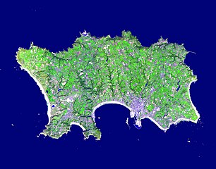
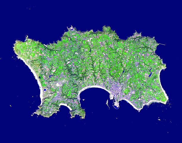
English: The Isle of Jersey (officially called the Bailiwick of Jersey) is the largest Channel Island, positioned in the Bay of Mont St Michel off the north-west coast of France. The island has a population of about 90,000, and covers about 90 square kilometers. The economy is based largely on international financial services, agriculture, and tourism. Called Caesaria in Roman times, Jersey became part of the Duchy of Normandy in 912. When William the Conqueror invaded and took the throne of England in 1066, the fortunes of Jersey then became linked to those in England, although the island manages its internal affairs through its own parliament, the States of Jersey. This image was acquired September 23, 2000, covers an area of 16.5 x 21 km, and is located at 49.2 degrees north latitude and 2.1 degrees west longitude |
||
| ದಿನಾಂಕ | Taken on ಸೆಪ್ಟೆಂಬರ್ ೨೩, ೨೦೦೦ | ||
| ಆಕರ |
|
||
| ಕರ್ತೃ | NASA/METI/AIST/Japan Space Systems, and U.S./Japan ASTER Science Team |
| Camera location | | View this and other nearby images on: OpenStreetMap |
|---|
.jpg¶ms=049.200000_N_-002.100000_E_globe:Earth_type:camera__&language=kn)
ಪರವಾನಗಿ
| This file is in the public domain in the United States because it was solely created by NASA. NASA copyright policy states that "NASA material is not protected by copyright unless noted". (See Template:PD-USGov, NASA copyright policy page or JPL Image Use Policy.) | ||
 |
Warnings:
|
ಕಡತದ ಇತಿಹಾಸ
ದಿನ/ಕಾಲ ಒತ್ತಿದರೆ ಆ ಸಮಯದಲ್ಲಿ ಈ ಕಡತದ ವಸ್ತುಸ್ಥಿತಿ ತೋರುತ್ತದೆ.
| ದಿನ/ಕಾಲ | ಕಿರುನೋಟ | ಆಯಾಮಗಳು | ಬಳಕೆದಾರ | ಟಿಪ್ಪಣಿ | |
|---|---|---|---|---|---|
| ಪ್ರಸಕ್ತ | ೨೧:೧೮, ೩೦ ಏಪ್ರಿಲ್ ೨೦೨೩ | | ೧,೪೦೦ × ೧,೧೦೦ (೨೩೧ KB) | OptimusPrimeBot | #Spacemedia - Upload of https://asterweb.jpl.nasa.gov/gallery/images/jersey.jpg via Commons:Spacemedia |
ಕಡತ ಬಳಕೆ
ಈ ಕೆಳಗಿನ ಪುಟವು ಈ ಚಿತ್ರಕ್ಕೆ ಸಂಪರ್ಕ ಹೊಂದಿದೆ:
ಜಾಗತಿಕ ಕಡತ ಉಪಯೋಗ
ಈ ಕಡತವನ್ನು ಕೆಳಗಿನ ಬೇರೆ ವಿಕಿಗಳೂ ಉಪಯೋಗಿಸುತ್ತಿವೆ:
- br.wikipedia.org ಮೇಲೆ ಬಳಕೆ
- en.wikipedia.org ಮೇಲೆ ಬಳಕೆ
- Minquiers and Ecréhous
- Saint Aubin, Jersey
- Les Dirouilles
- Vingtaine de Noirmont
- Vingtaine du Coin
- Vingtaine des Quennevais
- Vingtaine de la Moye
- Vingtaine de Samarès
- Grande Vingtaine (St Clement)
- Vingtaine du Rocquier
- Vingtaine de la Rocque
- Vingtaine des Marais
- Vingtaine de la Rue
- Vingtaine de Longueville
- Vingtaine du Rouge Bouillon
- Vingtaine de Bas du Mont au Prêtre
- Vingtaine du Mont à l'Abbé
- Vingtaine de Haut du Mont au Prêtre
- Vingtaine du Mont Cochon
- St Michael's Preparatory School
- Grouville Church
- St Peter la Rocque
- Vingtaine du Nord (St John)
- Vingtaine de Hérupe
- Vingtaine du Douet (St John)
- Template:Jersey-geo-stub
- Outline of Jersey
- Nicolle Tower
- Vingtaine de la Vallée
- Vingtaine du Coin Hâtain
- Vingtaine du Coin Motier
- Vingtaine du Coin Tourgis Sud
- Les Platons
- HM Prison La Moye
- Vingtaine du Nord (St Mary)
- Grainville School
- St Matthew's Church, Jersey
- Gulf of Saint-Malo
- Samarès Manor
- Saint Ouen's Manor
- FB Playing Fields
- Saint Helier Marina
- Vingtaine du Sud
- Vingtaine de Rozel
- Vingtaine de Faldouet
- Vingtaine de la Quéruée
- Vingtaine des Augrès
- Le Pinacle
- Beaulieu Convent School
ಈ ಫೈಲ್ನ ಹೆಚ್ಚು ಜಾಗತಿಕ ಬಳಕೆಯನ್ನು ವೀಕ್ಷಿಸಿ.
.jpg)
.jpg)