
ಚಿತ್ರ:Goa locator map.svg

Size of this PNG preview of this SVG file: ೨೭೪ × ೩೩೧ ಪಿಕ್ಸೆಲ್ಗಳು. ಇತರ ರೆಸಲ್ಯೂಶನ್ಗಳು: ೧೯೯ × ೨೪೦ ಪಿಕ್ಸೆಲ್ಗಳು | ೩೯೭ × ೪೮೦ ಪಿಕ್ಸೆಲ್ಗಳು | ೬೩೬ × ೭೬೮ ಪಿಕ್ಸೆಲ್ಗಳು | ೮೪೮ × ೧,೦೨೪ ಪಿಕ್ಸೆಲ್ಗಳು | ೧,೬೯೫ × ೨,೦೪೮ ಪಿಕ್ಸೆಲ್ಗಳು.
ಮೂಲ ಕಡತ (SVG ಫೈಲು, ಸುಮಾರಾಗಿ ೨೭೪ × ೩೩೧ ಚಿತ್ರಬಿಂದುಗಳು, ಫೈಲಿನ ಗಾತ್ರ: ೯೩ KB)
ಈ ಫೈಲು ವಿಕಿಮೀಡಿಯ ಕಾಮನ್ಸ್ನಲ್ಲಿ ಇರುವುದು. ಅಲ್ಲಿನ ವಿವರಣೆ ಪುಟವನ್ನೇ ಕೆಳಗೆ ತೋರಿಸಲಾಗಿದೆ. ಕಾಮನ್ಸ್ ಕೃತಿಸ್ವಾಮ್ಯತೆಯಿಂದ ಮುಕ್ತ ಫೈಲುಗಳ ಒಂದು ಆಗರ. ಅಲ್ಲಿ ನೀವೂ ಸಹಕರಿಸಬಹುದು. |
| ಶೀರ್ಷಿಕೆ |
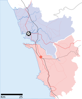
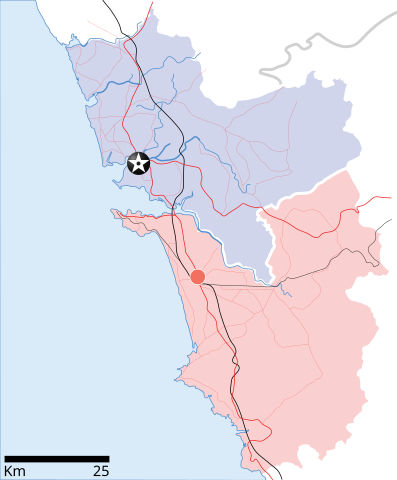
Goa locator map |
| Description |
Locator map for the state of w:Goa. Coordinates: top=15.811, bottom=14.861, left=73.567, right=74.287. |
| ದಿನಾಂಕ | |
| ಆಕರ |
ಸ್ವಂತ ಕೆಲಸ |
| ಸೃಷ್ಟಿಕರ್ತ | |
| ಅನುಮತಿ (ಈ ಕಡತವನ್ನು ಮರುಬಳಕೆ ಮಾಡಲಾಗುತ್ತಿದೆ) |
I, the copyright holder of this work, hereby publish it under the following license: ಈ ಕಡತ ಕ್ರಿಯೇಟಿವ್ ಕಾಮನ್ಸ್ Attribution
-Share Alike 3.0 Unported ಪರವಾನಗಿ ಹೊಂದಿದೆ.
|
| Geotemporal data | |
| Date depicted | second half of 20 century ಮತ್ತು 21 century |
| Georeferencing | If inappropriate please set warp_status = skip to hide. |
| Archival data | |
| Notes | Part of WikiProject India Maps |
ಕಡತದ ಇತಿಹಾಸ
ದಿನ/ಕಾಲ ಒತ್ತಿದರೆ ಆ ಸಮಯದಲ್ಲಿ ಈ ಕಡತದ ವಸ್ತುಸ್ಥಿತಿ ತೋರುತ್ತದೆ.
| ದಿನ/ಕಾಲ | ಕಿರುನೋಟ | ಆಯಾಮಗಳು | ಬಳಕೆದಾರ | ಟಿಪ್ಪಣಿ | |
|---|---|---|---|---|---|
| ಪ್ರಸಕ್ತ | ೧೬:೧೮, ೨೬ ಏಪ್ರಿಲ್ ೨೦೦೭ | | ೨೭೪ × ೩೩೧ (೯೩ KB) | Planemad | upd |
| ೧೬:೧೦, ೨೬ ಏಪ್ರಿಲ್ ೨೦೦೭ |  | ೨೭೪ × ೩೩೧ (೮೦ KB) | Planemad | upd | |
| ೨೩:೫೭, ೯ ಏಪ್ರಿಲ್ ೨೦೦೭ |  | ೨೭೪ × ೩೩೧ (೬೬ KB) | Planemad | {{WikiProject_India_Maps |Title=Goa locator map |Description=Locator map for the state of [w:Goa]] |Source= [http://www.bombayproperty.com/goamap.jpg Map of Goa], |Date=April 2007 |Author=w:user:Planemad }} Category:WikiProject India State Maps |
ಕಡತ ಬಳಕೆ
ಈ ಫೈಲನ್ನು ಬಳಸುವ ಯಾವ ಪುಟಗಳೂ ಇಲ್ಲ.
ಜಾಗತಿಕ ಕಡತ ಉಪಯೋಗ
ಈ ಕಡತವನ್ನು ಕೆಳಗಿನ ಬೇರೆ ವಿಕಿಗಳೂ ಉಪಯೋಗಿಸುತ್ತಿವೆ:
- ar.wikipedia.org ಮೇಲೆ ಬಳಕೆ
- ba.wikipedia.org ಮೇಲೆ ಬಳಕೆ
- ceb.wikipedia.org ಮೇಲೆ ಬಳಕೆ
- cy.wikipedia.org ಮೇಲೆ ಬಳಕೆ
- de.wikipedia.org ಮೇಲೆ ಬಳಕೆ
- en.wikipedia.org ಮೇಲೆ ಬಳಕೆ
- Farmagudi
- Zuari River
- Pilar, Goa
- Bardez
- Sonsogor
- Flora and fauna of Goa
- Sanguem
- Mollem, Goa
- Dabolim
- Template:Goa-geo-stub
- Aquem
- Bambolim
- Bandora, Goa
- Canacona
- Karapur
- Chicalim
- Chimbel
- Colvale
- Curti, Goa
- Davorlim
- Parcem
- Penha de França, Goa
- Queula
- Sancoale
- Sanquelim
- Sanvordem
- São José de Areal
- Valpoi
- Arpora
- Altinho, Goa
- Mardol, Goa
- Gokarna Math
- Baga, Goa
- Baga Creek
- Chapora Beach
- Terekhol River
- Kasarpal
- Revora
- Pale, Goa
- Agaçaim
- Priol
- Betul, Goa
- Bogmalo
- Adas Bank
- St Inez Creek
ಈ ಫೈಲ್ನ ಹೆಚ್ಚು ಜಾಗತಿಕ ಬಳಕೆಯನ್ನು ವೀಕ್ಷಿಸಿ.