
ಚಿತ್ರ:Calgary street map.png
ಈ ಮುನ್ನೋಟ ಗಾತ್ರ:೪೮೩ × ೬೦೦ ಪಿಕ್ಸೆಲ್ಗಳು. ಇತರ ರೆಸಲ್ಯೂಶನ್ಗಳು: ೧೯೩ × ೨೪೦ ಪಿಕ್ಸೆಲ್ಗಳು | ೩೮೬ × ೪೮೦ ಪಿಕ್ಸೆಲ್ಗಳು | ೯೬೦ × ೧,೧೯೨ ಪಿಕ್ಸೆಲ್ಗಳು.
ಮೂಲ ಕಡತ (೯೬೦ × ೧,೧೯೨ ಚಿತ್ರಬಿಂದು, ಫೈಲಿನ ಗಾತ್ರ: ೮೦೨ KB, MIME ಪ್ರಕಾರ: image/png)
ಈ ಫೈಲು ವಿಕಿಮೀಡಿಯ ಕಾಮನ್ಸ್ನಲ್ಲಿ ಇರುವುದು. ಅಲ್ಲಿನ ವಿವರಣೆ ಪುಟವನ್ನೇ ಕೆಳಗೆ ತೋರಿಸಲಾಗಿದೆ. ಕಾಮನ್ಸ್ ಕೃತಿಸ್ವಾಮ್ಯತೆಯಿಂದ ಮುಕ್ತ ಫೈಲುಗಳ ಒಂದು ಆಗರ. ಅಲ್ಲಿ ನೀವೂ ಸಹಕರಿಸಬಹುದು. |
ಸಾರಾಂಶ
| ವಿವರ |
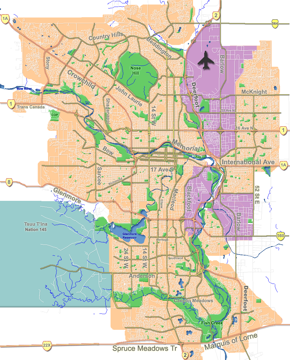
English: Outline map of Calgary. |
| ದಿನಾಂಕ | |
| ಆಕರ | GIS data |
| ಕರ್ತೃ | Qyd |
| ಇತರೆ ಆವೃತ್ತಿಗಳು |
Derivative works of this file: |
| Camera location | | View this and other nearby images on: OpenStreetMap |
|---|
ಪರವಾನಗಿ
| I, the copyright holder of this work, release this work into the public domain. This applies worldwide. In some countries this may not be legally possible; if so: I grant anyone the right to use this work for any purpose, without any conditions, unless such conditions are required by law. |
ಕಡತದ ಇತಿಹಾಸ
ದಿನ/ಕಾಲ ಒತ್ತಿದರೆ ಆ ಸಮಯದಲ್ಲಿ ಈ ಕಡತದ ವಸ್ತುಸ್ಥಿತಿ ತೋರುತ್ತದೆ.
| ದಿನ/ಕಾಲ | ಕಿರುನೋಟ | ಆಯಾಮಗಳು | ಬಳಕೆದಾರ | ಟಿಪ್ಪಣಿ | |
|---|---|---|---|---|---|
| ಪ್ರಸಕ್ತ | ೦೦:೦೧, ೮ ಅಕ್ಟೋಬರ್ ೨೦೦೭ | | ೯೬೦ × ೧,೧೯೨ (೮೦೨ KB) | Qyd | fix highway name |
| ೦೧:೧೪, ೧೯ ಏಪ್ರಿಲ್ ೨೦೦೭ |  | ೯೬೦ × ೧,೧೯೨ (೭೯೧ KB) | Qyd | spelling | |
| ೨೨:೫೮, ೧೮ ಸೆಪ್ಟೆಂಬರ್ ೨೦೦೬ |  | ೯೬೦ × ೧,೧೯೨ (೭೯೨ KB) | Qyd | outline industrial areas | |
| ೨೨:೫೦, ೧೬ ಆಗಸ್ಟ್ ೨೦೦೬ |  | ೯೬೦ × ೧,೧೯೨ (೮೦೨ KB) | Qyd | added airport symbol and highway shields | |
| ೨೦:೫೧, ೧೪ ಆಗಸ್ಟ್ ೨೦೦೬ |  | ೯೬೦ × ೧,೧೯೨ (೭೯೭ KB) | Qyd | fixed interchanges | |
| ೧೦:೧೬, ೧೪ ಆಗಸ್ಟ್ ೨೦೦೬ |  | ೯೬೦ × ೧,೧೯೨ (೭೦೦ KB) | Qyd | added city parks | |
| ೦೯:೪೯, ೧೪ ಆಗಸ್ಟ್ ೨೦೦೬ |  | ೯೬೦ × ೧,೧೯೨ (೬೪೫ KB) | Qyd | highways names added | |
| ೦೫:೪೭, ೧೪ ಆಗಸ್ಟ್ ೨೦೦೬ |  | ೯೬೦ × ೧,೧೯೨ (೪೯೧ KB) | Qyd | {{Information |Description= Outline map of Calgary |Source=GIS data |Date=Aug 2006 |Author=Qyd |Permission=All |other_versions=Image:CalgaryAB-map.png }} Category:Calgary Category:Maps of cities in Canada |
ಕಡತ ಬಳಕೆ
ಈ ಕೆಳಗಿನ 5 ಪುಟಗಳು ಈ ಚಿತ್ರಕ್ಕೆ ಸಂಪರ್ಕ ಹೊಂದಿವೆ:
ಜಾಗತಿಕ ಕಡತ ಉಪಯೋಗ
ಈ ಕಡತವನ್ನು ಕೆಳಗಿನ ಬೇರೆ ವಿಕಿಗಳೂ ಉಪಯೋಗಿಸುತ್ತಿವೆ:
- ar.wikipedia.org ಮೇಲೆ ಬಳಕೆ
- ast.wikipedia.org ಮೇಲೆ ಬಳಕೆ
- bh.wikipedia.org ಮೇಲೆ ಬಳಕೆ
- bn.wikipedia.org ಮೇಲೆ ಬಳಕೆ
- cy.wikipedia.org ಮೇಲೆ ಬಳಕೆ
- da.wikipedia.org ಮೇಲೆ ಬಳಕೆ
- en.wikipedia.org ಮೇಲೆ ಬಳಕೆ
- McMahon Stadium
- Glenmore Reservoir
- Alberta University of the Arts
- Fish Creek Provincial Park
- Heritage Park Historical Village
- Beltline, Calgary
- Nose Hill Park
- Bowness, Calgary
- Kensington, Calgary
- Chinatown, Calgary
- Tsuu T'ina 145
- Inglewood, Calgary
- McKenzie Lake, Calgary
- Eau Claire, Calgary
- Downtown Calgary
- Foothills Medical Centre
- McKenzie Towne, Calgary
- MNP Community & Sport Centre
- List of neighbourhoods in Calgary
- Lakeview, Calgary
- Chinook Centre
- Parkdale, Calgary
- Mission, Calgary
- Marda Loop, Calgary
- Bankview, Calgary
- Mount Royal, Calgary
- Springbank Hill, Calgary
- List of airports in the Calgary area
- Telus Spark Science Centre
- Edgemont, Calgary
- Pineridge, Calgary
- Edworthy Park
- Lake Bonavista, Calgary
- Confederation Park, Calgary
- University Heights, Calgary
- The Military Museums
- Transportation in Calgary
- User:Qyd/Maps
- Market Mall
ಈ ಫೈಲ್ನ ಹೆಚ್ಚು ಜಾಗತಿಕ ಬಳಕೆಯನ್ನು ವೀಕ್ಷಿಸಿ.