
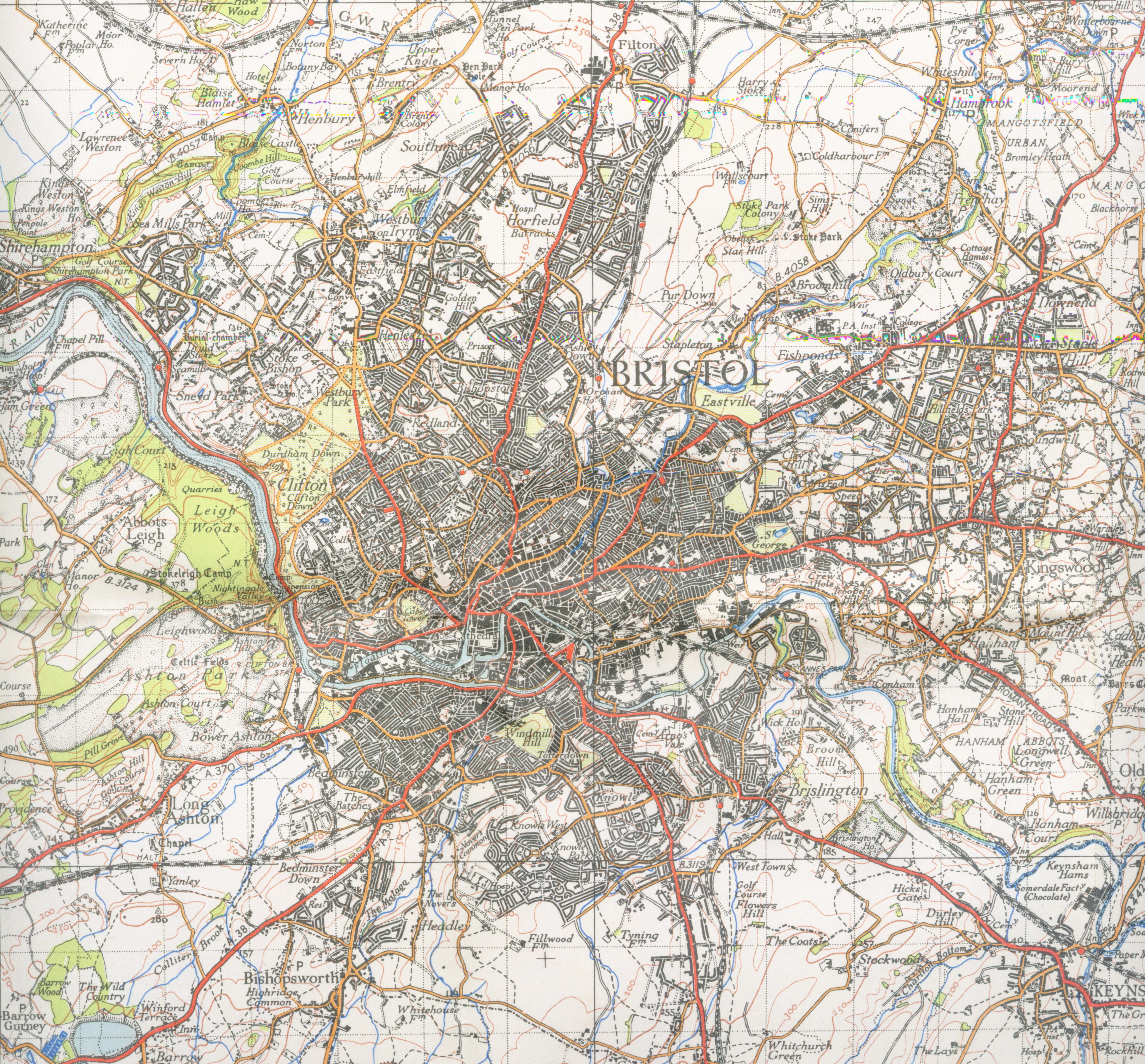
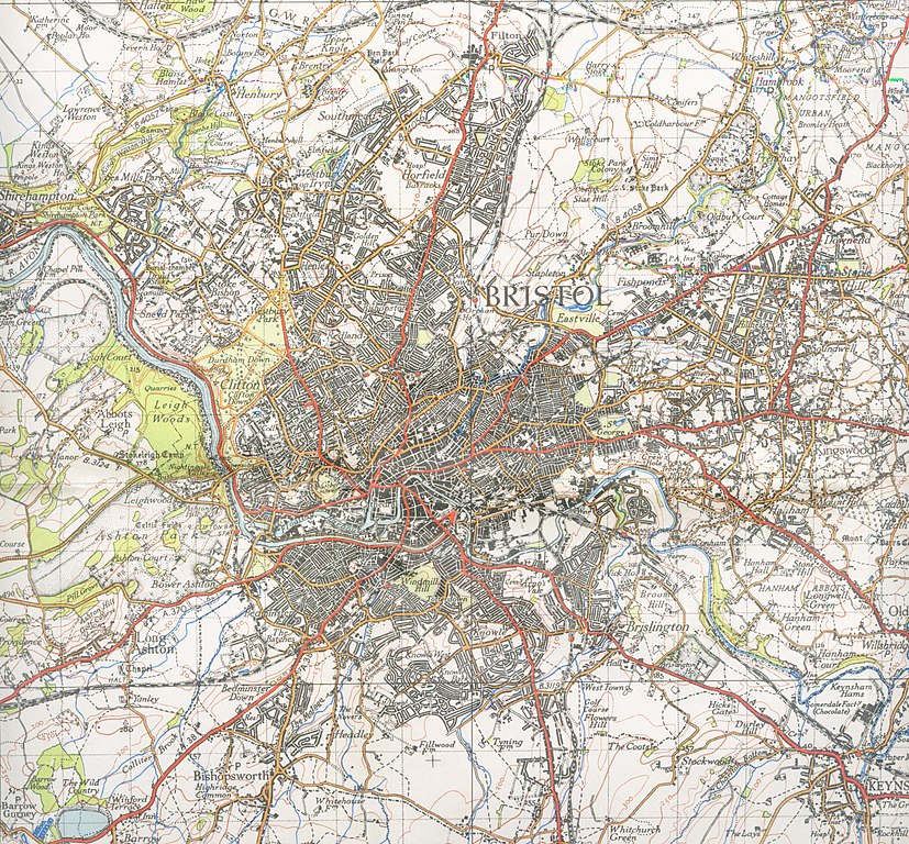
ಚಿತ್ರ:Bristol map 1946.jpg
ಈ ಮುನ್ನೋಟ ಗಾತ್ರ:೬೪೫ × ೫೯೯ ಪಿಕ್ಸೆಲ್ಗಳು. ಇತರ ರೆಸಲ್ಯೂಶನ್ಗಳು: ೨೫೮ × ೨೪೦ ಪಿಕ್ಸೆಲ್ಗಳು | ೫೧೭ × ೪೮೦ ಪಿಕ್ಸೆಲ್ಗಳು | ೮೨೭ × ೭೬೮ ಪಿಕ್ಸೆಲ್ಗಳು | ೧,೧೦೨ × ೧,೦೨೪ ಪಿಕ್ಸೆಲ್ಗಳು | ೨,೨೦೪ × ೨,೦೪೮ ಪಿಕ್ಸೆಲ್ಗಳು | ೪,೯೬೦ × ೪,೬೦೮ ಪಿಕ್ಸೆಲ್ಗಳು.
ಮೂಲ ಕಡತ (೪,೯೬೦ × ೪,೬೦೮ ಚಿತ್ರಬಿಂದು, ಫೈಲಿನ ಗಾತ್ರ: ೩.೭೫ MB, MIME ಪ್ರಕಾರ: image/jpeg)
ಈ ಫೈಲು ವಿಕಿಮೀಡಿಯ ಕಾಮನ್ಸ್ನಲ್ಲಿ ಇರುವುದು. ಅಲ್ಲಿನ ವಿವರಣೆ ಪುಟವನ್ನೇ ಕೆಳಗೆ ತೋರಿಸಲಾಗಿದೆ. ಕಾಮನ್ಸ್ ಕೃತಿಸ್ವಾಮ್ಯತೆಯಿಂದ ಮುಕ್ತ ಫೈಲುಗಳ ಒಂದು ಆಗರ. ಅಲ್ಲಿ ನೀವೂ ಸಹಕರಿಸಬಹುದು. |
| ವಿವರ | Map of Bristol from 1946. Scale 1 inch to the mile 600DPI Sheet 156 | ||||
| ದಿನಾಂಕ | |||||
| ಆಕರ | OS | ||||
| ಕರ್ತೃ | OS | ||||
| ಅನುಮತಿ (ಈ ಕಡತವನ್ನು ಮರುಬಳಕೆ ಮಾಡಲಾಗುತ್ತಿದೆ) |
|

| Camera location | | View this and other nearby images on: OpenStreetMap |
|---|
ಕಡತದ ಇತಿಹಾಸ
ದಿನ/ಕಾಲ ಒತ್ತಿದರೆ ಆ ಸಮಯದಲ್ಲಿ ಈ ಕಡತದ ವಸ್ತುಸ್ಥಿತಿ ತೋರುತ್ತದೆ.
| ದಿನ/ಕಾಲ | ಕಿರುನೋಟ | ಆಯಾಮಗಳು | ಬಳಕೆದಾರ | ಟಿಪ್ಪಣಿ | |
|---|---|---|---|---|---|
| ಪ್ರಸಕ್ತ | ೦೩:೪೦, ೨ ಡಿಸೆಂಬರ್ ೨೦೦೭ | | ೪,೯೬೦ × ೪,೬೦೮ (೩.೭೫ MB) | Geni | trying again |
| ೨೨:೫೦, ೧೬ ಸೆಪ್ಟೆಂಬರ್ ೨೦೦೭ |  | ೪,೩೫೨ × ೪,೮೦೦ (೩.೩೯ MB) | Geni | {{Information |Description=Map of Bristol from 1946. Scale 1 inch to the mile 600DPI Sheet 156 |Source=OS |Date=1946 |Author=OS |Permission=none needed |other_versions= }} {{oldOS}} Category:Maps of cities in the United Kingdom Category:Bristol |
ಕಡತ ಬಳಕೆ
ಈ ಕೆಳಗಿನ ಪುಟವು ಈ ಚಿತ್ರಕ್ಕೆ ಸಂಪರ್ಕ ಹೊಂದಿದೆ:
ಜಾಗತಿಕ ಕಡತ ಉಪಯೋಗ
ಈ ಕಡತವನ್ನು ಕೆಳಗಿನ ಬೇರೆ ವಿಕಿಗಳೂ ಉಪಯೋಗಿಸುತ್ತಿವೆ:
- azb.wikipedia.org ಮೇಲೆ ಬಳಕೆ
- en.wikipedia.org ಮೇಲೆ ಬಳಕೆ
- he.wikipedia.org ಮೇಲೆ ಬಳಕೆ